
Makati–Mandaluyong Bridge
Makati–Mandaluyong Bridge | |
|---|---|
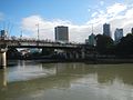
 The Makati–Mandaluyong Bridge from the Mandaluyong side | |
| Coordinates | 14°34′10″N 121°01′57″E / 14.5694°N 121.0325°E |
| Carries | Vehicular traffic and pedestrians |
| Crosses | Pasig River |
| Locale | Makati and Mandaluyong, Metro Manila, Philippines |
| Maintained by | Department of Public Works and Highways 2nd District Engineering Office[1] |
| Segment ID | S04551LZ (northbound) S04552LZ (southbound) B04891LZ (bridge)[1] |
| Preceded by | Lambingan Bridge |
| Followed by | Estrella–Pantaleon Bridge |
| Characteristics | |
| Material | Prestressed concrete, box girder[2] |
| Total length | 339 m (1,112 ft) (bridge) 0.29 km (0.18 mi) (road)[1] |
| Width | 8.93 m (29.3 ft)[3] |
| Height | 6 m (20 ft)[3] |
| Load limit | 20 metric tons (20 long tons; 22 short tons)[3] |
| No. of lanes | 4 (2 per direction)[3] |
| History | |
| Construction start | Post-1970 |
| Construction end | 1986[3] |
| Statistics | |
| Daily traffic | 42 thousand vehicles (2013)[4] |
| Location | |
 | |
The Makati–Mandaluyong Bridge is a four-lane road bridge crossing the Pasig River between Makati and Mandaluyong in Metro Manila, Philippines. It connects P. Burgos Extension, a continuation of Makati Avenue in Poblacion, Makati at the south bank of the river to Coronado Street in Hulo, Mandaluyong at its north bank. The bridge was opened in 1986.[1]
The Hulo jeepney terminal, which serves intra-city jeepney and tricycle routes in Mandaluyong, was established in 2015 and can be found under and adjacent to the bridge.[5] Until the opening of the Estrella–Pantaleon Bridge in 2011, the Makati–Mandaluyong Bridge was the only bridge connecting the two cities other than the Guadalupe Bridge that carries EDSA.[6]
Gallery
[edit]-
 The bridge as seen from the north bank
 -
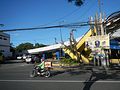 Pedestrian access for the bridge from Mandaluyong
 -
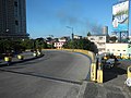
 The bridge approaching Makati
 -
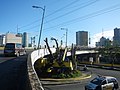
 The bridge approaching Mandaluyong
 -
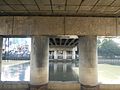 Bridge pier
 -
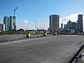 Road bridge


References
[edit]- ^ a b c d "Metro Manila 2nd". www.dpwh.gov.ph. Retrieved November 21, 2021.
- ^ "The study on the improvement of existing bridges along Pasig River and Marikina River in the Republic of the Philippines final report". Japan International Cooperation Agency: Part II - Masterplan, page 20. July 2004.
- ^ a b c d e "Road and Bridge Inventory". www.dpwh.gov.ph. Retrieved November 21, 2021.
- ^ "The project for study on improvement of bridges through disaster mitigating measures for large scale earthquakes in the Republic of the Philippines final report". Japan International Cooperation Agency: 25. December 2013.
- ^ "Hulo jeepney & tricycle terminal with park inaugurated". Mandaluyong City Government. Retrieved September 15, 2022.
- ^ "More bridges across Pasig". Philstar.com. Retrieved November 21, 2021.
This article about a bridge in the Philippines is a stub. You can help Wikipedia by expanding it. |