
Portal:Connecticut
The Connecticut Portal

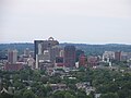
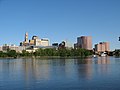
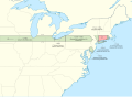
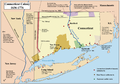
Connecticut (/kəˈnɛtɪkət/ kə-NET-ik-ət) is the southernmost state in the New England region of the Northeastern United States. It borders Rhode Island to the east, Massachusetts to the north, New York to the west, and Long Island Sound to the south. Its capital is Hartford, and its most populous city is Bridgeport. Connecticut lies between the major hubs of New York City and Boston along the Northeast Corridor, where the New York metropolitan area, which includes six of Connecticut's seven largest cities, extends well into the southwestern part of the state. Connecticut is the third-smallest state by area after Rhode Island and Delaware, and the 29th most populous with slightly more than 3.6 million residents as of 2020, ranking it fourth among the most densely populated U.S. states.
The state is named after the Connecticut River, the longest in New England which roughly bisects the state and drains into the Long Island Sound between the towns of Old Saybrook and Old Lyme. The name of the river is in turn derived from anglicized spellings of Quinnetuket, a Mohegan-Pequot word for "long tidal river". Before the arrival of the first European settlers, the region was inhabited by various Algonquian tribes. In 1633, the Dutch West India Company established a small, short-lived settlement called House of Hope in Hartford. Half of Connecticut was initially claimed by the Dutch colony New Netherland, which included much of the land between the Connecticut and Delaware Rivers, although the first major settlements were established by the English around the same time. Thomas Hooker led a band of followers from the Massachusetts Bay Colony to form the Connecticut Colony, while other settlers from Massachusetts founded the Saybrook Colony and the New Haven Colony; both merged into the former by 1664.
Connecticut's official nickname, the "Constitution State", refers to the Fundamental Orders adopted by the Connecticut Colony in 1639, which is considered by some to be the first written constitution in Western history. As one of the Thirteen Colonies that rejected British rule during the American Revolution, Connecticut was influential in the development of the federal government of the United States. In 1787, Roger Sherman and Oliver Ellsworth, state delegates to the Constitutional Convention, proposed a compromise between the Virginia and New Jersey Plans; its bicameral structure for Congress, with a respectively proportional and equal representation of the states in the House of Representatives and Senate, was adopted and remains to this day. In January 1788, Connecticut became the fifth state to ratify the Constitution. (Full article...)
 Recognized content -
U.S. Route 5 (US 5), a north–south United States Numbered Highway that is generally paralleled by Interstate 91 (I-91), begins at the city of New Haven in Connecticut and heads north through western Massachusetts and eastern Vermont to the international border with Canada. Within Connecticut, US 5 proceeds north from New Haven and passes through Meriden and Hartford toward Springfield, Massachusetts.
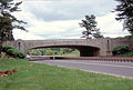
US 5 begins at exit 5 of I-91 northeast of Downtown New Haven, heading north through the suburbs of New Haven. It crosses the Quinnipiac River in North Haven, shifting eastward to a different road. US 5 continues north through the town of Wallingford before entering the city of Meriden. North of Meriden, it becomes a four-lane arterial road known as the Berlin Turnpike, where a long overlap with Route 15 also begins. US 5 continues through the southern suburbs of Hartford along the Berlin Turnpike, shifting just south of the city line to the Wilbur Cross Highway, a freeway. The Wilbur Cross Highway bypasses Downtown Hartford and crosses the Connecticut River on the Charter Oak Bridge into East Hartford. From here, US 5 exits the Wilbur Cross Highway and runs along a four-lane, divided surface road to South Windsor before returning to a two-lane road the rest of the way to the Massachusetts state line in Enfield. (Full article...)General images -
-
-
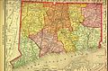 1895 map from Rand McNally (from History of Connecticut)
 -
-
-

-
-
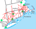
 Map of Connecticut showing major highways. (from Transportation in Connecticut)
 -
-

-
 School zones generally have a speed limit of 25 mph. (from Transportation in Connecticut)
 -
-
 A map showing Connecticut's land claims. (from History of Connecticut)
 -
-
-
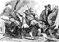 Pequot War of 1637 (from History of Connecticut)
 -
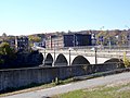
 Some bridges on the Merritt Parkway were constructed by workers paid by the US Works Progress Administration (from History of Connecticut)
 -
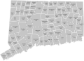 A map showing Connecticut's towns in 1770. (from History of Connecticut)
 -
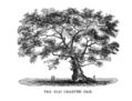 The Charter Oak in Hartford (from History of Connecticut)
 -

-
-
 The New Haven system (from History of Connecticut)
 -

-
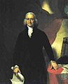 Governor Jonathan Trumbull (from History of Connecticut)
 -
-
-

-
 Map showing the Connecticut, New Haven, and Saybrook colonies and the CT-NY dispute (from History of Connecticut)
 -
-

-
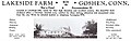 A 1942 advertisement for recreational lodging in Goshen stating that the facility is not a hotel and caters to Christian clientele specifically. (from History of Connecticut)
 -
-

-

-


Selected picture -

State facts
- Nicknames: The Provisions State, The Land of Steady Habits, The Constitution State, The Nutmeg State
- Capital: Hartford
- Governor: Ned Lamont (D)
- Lieutenant Governor: Susan Bysiewicz (D)
- Secretary of State: Stephanie Thomas (D)
- Attorney General: William Tong (D)
- Senators: Chris Murphy (D), Richard Blumenthal (D)
- Representatives: Jahana Hayes (D), Jim Himes (D), Joe Courtney (D), John B. Larson (D), Rosa DeLauro (D)
- Total area: 5,543 mi2
- Land: 4,845 mi2
- Water: 698 mi2
- Highest elevation: 2,379 ft (Mount Frissell)
- Population 3,576,452 (2015 est)
- Admission to the Union: January 9, 1788 (5th)
State symbols:
- Animal: Sperm whale
- Bird: American Robin
- Fish: American Shad
- Flower: Mountain Laurel
- Fossil: Dinosaur Track
- Insect: European Praying Mantis
- Ship: USS Nautilus (SSN-571)
- Songs: Yankee Doodle
- Tree: Charter Oak
- Mineral: Almandine
Selected article -

Yale University is a private Ivy League research university in New Haven, Connecticut. Founded in 1701, Yale is the third-oldest institution of higher education in the United States, and one of the nine colonial colleges chartered before the American Revolution.
Yale was established as the Collegiate School in 1701 by Congregationalist clergy of the Connecticut Colony. Originally restricted to instructing ministers in theology and sacred languages, the school's curriculum expanded, incorporating humanities and sciences by the time of the American Revolution. In the 19th century, the college expanded into graduate and professional instruction, awarding the first PhD in the United States in 1861 and organizing as a university in 1887. Yale's faculty and student populations grew rapidly after 1890 due to the expansion of the physical campus and its scientific research programs. (Full article...)Did you know? -
- ... that a Connecticut radio station was "the loser in a survival-of-the-fittest battle"?
- ... that under a new Connecticut law, abortion providers in the state can countersue anyone who sues them under the Texas Heartbeat Act?
- ... that Nathan Agostinelli stomped on a Viet Cong flag during his campaign for Connecticut State Comptroller?
- ... that Darien, Connecticut, was once home to a train station built inside a cemetery?
- ... that a variety of the Connecticut field pumpkin is known as "the original commercial jack-o'-lantern pumpkin"?
- ... that a Connecticut TV station was dedicated to the state's first female governor, Ella Grasso, whose son was a minority owner?
In the news

- February 10: Disney to shut down Blue Sky Studios, animation studio behind 'Ice Age'
- October 17: Hundreds arrested for 'dark web' child porn by international task force
- October 3: World War II era plane crashes in Connecticut, US, killing at least seven
- February 21: Sixteen states sue U.S. President Trump to stop declaration of emergency for border wall
Categories

Related WikiProjects

WikiProject Connecticut • WikiProject Connecticut routes • WikiProject UCONN
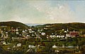
Selected panorama

Topics

Related portals
Associated Wikimedia
The following Wikimedia Foundation sister projects provide more on this subject:
-
 Commons
Free media repository -
 Wikibooks
Free textbooks and manuals -
 Wikidata
Free knowledge base -
 Wikinews
Free-content news -
 Wikiquote
Collection of quotations -
 Wikisource
Free-content library -
 Wikiversity
Free learning tools -
 Wikivoyage
Free travel guide -
 Wiktionary
Dictionary and thesaurus


