
Portal:Tropical cyclones
The Tropical Cyclones Portal

A tropical cyclone is a storm system characterized by a large low-pressure center, a closed low-level circulation and a spiral arrangement of numerous thunderstorms that produce strong winds and heavy rainfall. Tropical cyclones feed on the heat released when moist air rises, resulting in condensation of water vapor contained in the moist air. They are fueled by a different heat mechanism than other cyclonic windstorms such as Nor'easters, European windstorms and polar lows, leading to their classification as "warm core" storm systems. Most tropical cyclones originate in the doldrums, approximately ten degrees from the Equator.
The term "tropical" refers to both the geographic origin of these systems, which form almost exclusively in tropical regions of the globe, as well as to their formation in maritime tropical air masses. The term "cyclone" refers to such storms' cyclonic nature, with anticlockwise rotation in the Northern Hemisphere and clockwise rotation in the Southern Hemisphere. Depending on its location and intensity, a tropical cyclone may be referred to by names such as "hurricane", "typhoon", "tropical storm", "cyclonic storm", "tropical depression" or simply "cyclone".
Types of cyclone: 1. A "Typhoon" is a tropical cyclone located in the North-west Pacific Ocean which has the most cyclonic activity and storms occur year-round. 2. A "Hurricane" is also a tropical cyclone located at the North Atlantic Ocean or North-east Pacific Ocean which have an average storm activity and storms typically form between May 15 and November 30. 3. A "Cyclone" is a tropical cyclone that occurs in the South Pacific and Indian Oceans.
Selected named cyclone -

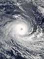
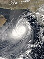
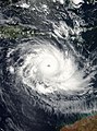
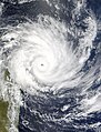
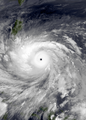
Very Intense Tropical Cyclone Freddy, also known as Severe Tropical Cyclone Freddy, was an exceptionally long-lived, powerful, and deadly tropical cyclone that traversed the southern Indian Ocean for more than five weeks in February and March 2023. Freddy was the longest-lasting tropical cyclone ever recorded worldwide, and produced the most accumulated cyclone energy—a metric used to measure the total energy generated by tropical cyclones—of any individual cyclone on record globally. Additionally, it is the third-deadliest tropical cyclone recorded in the Southern Hemisphere, only behind 2019's Cyclone Idai and the 1973 Flores cyclone.
Freddy originated from a tropical low that was located south of the Indonesian archipelago on 4 February 2023. As it traveled westward across the Indian Ocean, the storm quickly intensified, becoming a Category 4 severe tropical cyclone on the Australian scale. Freddy moved into the South-West Indian Ocean, where it reached its peak intensity with 10-minute sustained winds of 230 km/h (145 mph) and a central atmospheric pressure of 927 hPa (27.37 inHg), making it a very intense tropical cyclone. Meanwhile, 1-minute sustained winds reached 270 km/h (165 mph), corresponding to Category 5-equivalent intensity on the Saffir–Simpson scale. After reaching its peak intensity, the cyclone moved toward the northern Mascarene Islands and made landfall near Mananjary, Madagascar on 21 February. It weakened further across Madagascar but regained strength upon reaching the Mozambique Channel, where it intensified and made its second landfall near Vilankulos, Mozambique on 24 February. After moving across Mozambique, the cyclone endured and re-entered the channel on 1 March. It then regained its tropical characteristics and started moving along the coast of Madagascar. Freddy intensified again before making its final landfall near Quelimane, Mozambique on 11 March. It then rapidly weakened as it moved inland and dissipated by 14 March. (Full article...)
Selected article -

The Automated Tropical Cyclone Forecasting System (ATCF) is a piece of software originally developed to run on a personal computer for the Joint Typhoon Warning Center (JTWC) in 1988, and the National Hurricane Center (NHC) in 1990. ATCF remains the main piece of forecasting software used for the United States Government, including the JTWC, NHC, and Central Pacific Hurricane Center. Other tropical cyclone centers in Australia and Canada developed similar software in the 1990s. The data files with ATCF lie within three decks, known as the a-, b-, and f-decks. The a-decks include forecast information, the b-decks contain a history of center fixes at synoptic hours, and the f-decks include the various fixes made by various analysis center at various times. In the years since its introduction, it has been adapted to Unix and Linux platforms. (Full article...)
Selected image -

Selected season -

The 2016 Atlantic hurricane season was the first above-average hurricane season since 2012, producing 15 named storms, 7 hurricanes and 4 major hurricanes. The season officially started on June 1 and ended on November 30, though the first storm, Hurricane Alex which formed in the Northeastern Atlantic, developed on January 12, being the first hurricane to develop in January since 1938. The final storm, Otto, crossed into the Eastern Pacific on November 25, a few days before the official end. Following Alex, Tropical Storm Bonnie brought flooding to South Carolina and portions of North Carolina. Tropical Storm Colin in early June brought minor flooding and wind damage to parts of the Southeastern United States, especially Florida. Hurricane Earl left 94 fatalities in the Dominican Republic and Mexico, 81 of which occurred in the latter. In early September, Hurricane Hermine, the first hurricane to make landfall in Florida since Hurricane Wilma in 2005, brought extensive coastal flooding damage especially to the Forgotten and Nature coasts of Florida. Hermine was responsible for five fatalities and about $550 million (2016 USD) in damage.
The strongest, costliest, and deadliest storm of the season was Hurricane Matthew, the southernmost Category 5 Atlantic hurricane on record and the first to reach that intensity since Felix in 2007, ending the longest streak of seasons without a hurricane of such intensity in the Satellite Era. With at least 603 deaths attributed to it, Matthew was the deadliest Atlantic hurricane since Stan of 2005. Furthermore, damage from Matthew is estimated to be at least $16.5 billion, making it the ninth costliest Atlantic hurricane on record at the time. Hurricane Nicole became the first major hurricane to directly impact Bermuda since Hurricane Fabian in 2003, leaving widespread but relatively moderate damage on the island. The final tropical cyclone of the season – Hurricane Otto – brought severe flooding to Central America in November, particularly in Costa Rica and Nicaragua. Otto left 23 deaths and about $190 million in damage. On November 25, the storm emerged into the Eastern Pacific basin, the first such occurrence since Hurricane Cesar–Douglas in 1996. Most of the season's tropical cyclones impacted land, and nine of those storms caused loss of life. Collectively, the storms left at least 736 fatalities and $17.49 billion in damage, making the season the costliest since 2012. (Full article...)
Related portals
Currently active tropical cyclones

Italicized basins are unofficial.
- East and Central Pacific (2024)
- No active systems
- North Indian Ocean (2024)
- No active systems
- Mediterranean (2024–25)
- No active systems
- Australian region (2024–25)
- No active systems
- South Pacific (2024–25)
- No active systems
- South Atlantic (2024–25)
- No active systems
Last updated: 20:44, 3 October 2024 (UTC)
Tropical cyclone anniversaries

October 3
- 1963 - Hurricane Flora reached its peak as a Category 4 hurricane with 225 km/h (140 mph) winds in the Caribbean Sea. Flora killed over 7,000 people, mostly in Cuba and Haiti as a result of excessive rainfall.
- 2015 - Hurricane Joaquin (pictured) reaches peak intensity as a high-end Category 4 hurricane, after impacting the Bahamas.

October 4
- 1995 - Hurricane Opal made landfall on the Florida panhandle with 185 km/h (115 mph) winds. Opal caused over $3 billion of damage in Florida alone.
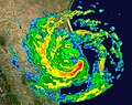
- 2016 - Hurricane Matthew (pictured) affects the Caribbean as a Category 4 major hurricane, where more than 1,000 people were killed and damages recorded nearly about $15 billion.

October 5
- 1864 - The 1864 Calcutta cyclone hit India near Calcutta, devastating the city and killing about 60,000 people.
- 1999 - Typhoon Dan reaches its maximum intensity as a Category 3 typhoon with 10-minute sustained winds of 150 km/h (90 mph)
- 2003 - Tropical Storm Larry (pictured) makes landfall over in Paraíso, Tabasco. Damages from Larry were recorded at $53.6 million.
Did you know…


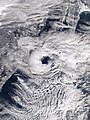
- …that the Joint Typhoon Warning Center considers that Typhoon Vera (pictured) of 1986 is actually two distinct systems, formed from two separated low-level circulations?
- …that Cyclone Freddy (track pictured) in 2023 was the longest-lasting tropical cyclone worldwide?
- …that Cyclone Raquel (track pictured) travelled between the Australian and South Pacific basins between the 2014–15 and 2015–16 seasons, spanning both seasons in both basins?
- …that Hurricane Otis (pictured) in 2023 was the first Pacific hurricane to make landfall at Category 5 intensity and surpassed Hurricane Patricia as the strongest landfalling Pacific hurricane on record?
General images -
-
 (from Cyclone)
 -
 The aftermath of Hurricane Katrina in Gulfport, Mississippi. Katrina was the costliest tropical cyclone in United States history. (from Effects of tropical cyclones)
 -
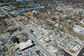
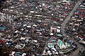 Aerial image of destroyed houses in Tacloban, following Typhoon Haiyan (from Effects of tropical cyclones)
 -
 (from Cyclone)
 -
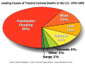 Percentages of hurricane deaths in the United States from 1970 to 1999. (from Effects of tropical cyclones)
 -
 An example of a chart for Matthew showing its five-day forecast track (from Tropical cyclone preparedness)
 -
 A polar low over the Sea of Japan in December 2009 (from Cyclone)
 -
 Surface weather map of the 1935 Labor Day hurricane moving up the west coast of Florida (from Tropical cyclone observation)
 -
 Flooding in Port Arthur, Texas caused by Hurricane Harvey. Harvey was the wettest and second-costliest tropical cyclone in United States history. (from Effects of tropical cyclones)
 -
-
 Hurricane Isabel (2003)'s effect on the North Carolina Outer Banks (from Effects of tropical cyclones)
 -
 Radar image of Hurricane Erika making landfall over Northeastern Mexico (from Tropical cyclone observation)
 -
 Tropical cyclones form when the energy released by the condensation of moisture in rising air causes a positive feedback loop over warm ocean waters. (from Cyclone)
 -
 (from Cyclone)
 -
 Personnel and equipment from the National Guard of the United States en route to Hurricane Florence response efforts in 2018
 -
-
 A fictitious synoptic chart of an extratropical cyclone affecting the UK and Ireland. The blue arrows between isobars indicate the direction of the wind, while the "L" symbol denotes the centre of the "low". Note the occluded, cold and warm frontal boundaries. (from Cyclone)
 -
 (from Cyclone)
 -
-
 The initial extratropical low-pressure area forms at the location of the red dot on the image. It is usually perpendicular (at a right angle to) the leaf-like cloud formation seen on satellite during the early stage of cyclogenesis. The location of the axis of the upper level jet stream is in light blue. (from Cyclone)
 -
 The number of $1 billion Atlantic hurricanes almost doubled from the 1980s to the 2010s, and inflation-adjusted costs have increased more than elevenfold. The increases have been attributed to climate change and to greater numbers of people moving to coastal areas. (from Effects of tropical cyclones)
 -
 Broken concrete utility pole in Puerto Rico after Hurricane Maria in 2017, which ranks fourth in costliest US tropical cyclones. (from Effects of tropical cyclones)
 -
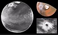 Cyclone on Mars, imaged by the Hubble Space Telescope (from Cyclone)
 -
 Chart with concurrent information for Hurricane Arlene and Tropical Storm Bret logged and plotted (from Tropical cyclone preparedness)
 -
 Hurricane response involves working in hazardous conditions, including contamination and electrocution hazards from floodwater.
 -
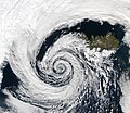 An extratropical cyclone near Iceland (from Cyclone)
 -
 Hurricane Catarina, a rare South Atlantic tropical cyclone viewed from the International Space Station on March 26, 2004 (from Cyclone)
 -
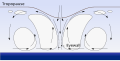
 The dangerous semicircle is the upper-right corner, with the arrow marking the direction of motion of a Northern Hemisphere storm. Note that typhoons, etc. are asymmetrical, and semicircle is a convenient misnomer. (from Effects of tropical cyclones)
 -
 All but the most expensive bottles of water were sold out at this Publix supermarket before Hurricane Irma; in the week preceding the storm, water sold out soon after shipments arrived (from Tropical cyclone preparedness)
 -
 2017 Atlantic hurricane season summary map (from Cyclone)
 -
-
 (from Cyclone)
 -

-
 Comparison between extratropical and tropical cyclones on surface analysis (from Cyclone)
.jpg)


_(50).jpg)


.jpg)


.jpg)


.png)
.png)

 Featured list -
.jpg)
Category 4, the second-highest classification on the Saffir–Simpson scale, is used for tropical cyclones that have winds of 130–156 mph (209–251 km/h; 113–136 kn). The division of the eastern and central Pacific basins occurs at 140° W; the eastern Pacific covers area east of 140° W, while the central Pacific extends between 140° W to 180° W. Both basins' division points are at 66° N as a northern point and the equator as the southern point. As of 2024[update], 143 hurricanes have attained Category 4 status in the northeastern Pacific basins. This list does not include storms that also attained Category 5 status on the scale.
Numerous climatological factors influence the formation of hurricanes in the Pacific basins. The North Pacific High and Aleutian Low, usually present between January and April, cause strong wind shear and unfavorable conditions for the development of hurricanes. During its presence, El Niño results in increased numbers of powerful hurricanes through weaker wind shear, while La Niña reduces the number of such hurricanes through the opposite. Global warming may also influence the formation of tropical cyclones in the Pacific basin. During a thirty-year period with two sub-periods, the first between 1975 and 1989 and the second between 1990 and 2004, an increase of thirteen Category 4 or 5 storms was observed from the first sub-period.
(Full article...)Topics

Subcategories

Related WikiProjects
WikiProject Tropical cyclones is the central point of coordination for Wikipedia's coverage of tropical cyclones. Feel free to help!
WikiProject Weather is the main center point of coordination for Wikipedia's coverage of meteorology in general, and the parent project of WikiProject Tropical cyclones. Three other branches of WikiProject Weather in particular share significant overlaps with WikiProject Tropical cyclones:
- The Non-tropical storms task force coordinates most of Wikipedia's coverage on extratropical cyclones, which tropical cyclones often transition into near the end of their lifespan.
- The Floods task force takes on the scope of flooding events all over the world, with rainfall from tropical cyclones a significant factor in many of them.
- WikiProject Severe weather documents the effects of extreme weather such as tornadoes, which landfalling tropical cyclones can produce.
Things you can do
 |
Here are some tasks awaiting attention:
|
Wikimedia
The following Wikimedia Foundation sister projects provide more on this subject:
-
 Commons
Free media repository -
 Wikibooks
Free textbooks and manuals -
 Wikidata
Free knowledge base -
 Wikinews
Free-content news -
 Wikiquote
Collection of quotations -
 Wikisource
Free-content library -
 Wikiversity
Free learning tools -
 Wikivoyage
Free travel guide -
 Wiktionary
Dictionary and thesaurus


