
Manyberries
Manyberries | |
|---|---|
Hamlet | |
 Former railroad station | |
 Manyberries | |
| Coordinates: 49°24′06″N 110°41′38″W / 49.40167°N 110.69389°W | |
| Country | Canada |
| Province | Alberta |
| Region | Southern Alberta |
| Census division | 2 |
| Municipal district | County of Forty Mile No. 8 |
| Elevation | 930 m (3,050 ft) |
| Population (1991)[1] | |
| • Total | 96 |
| Time zone | UTC−7 (MST) |
| • Summer (DST) | UTC−6 (MDT) |
| Postal code span | |
| Area code | +1-403 |
| Highways | Highway 61 |
| Waterways | Pakowki Lake, Manyberries Creek |
Manyberries is a hamlet in Alberta, Canada within the County of Forty Mile No. 8.[2] It is located approximately 85 km (53 mi) south of Medicine Hat, at the eastern end of Highway 61 (the Red Coat Trail).
Geography
[edit]Climate
[edit]Manyberries experiences a semi-arid climate (Köppen climate classification BSk). Winters are long, cold and dry, while summers are relatively short but very warm. Precipitation is low, with an annual average of 353 mm, and is concentrated in the warmer months. Manyberries is the sunniest spot in Canada, receiving an average of 2,567 hours of sunshine per year.
| Climate data for Manyberries (Onefour Research Farm), 1971–2000 normals, extremes 1928–present | |||||||||||||
|---|---|---|---|---|---|---|---|---|---|---|---|---|---|
| Month | Jan | Feb | Mar | Apr | May | Jun | Jul | Aug | Sep | Oct | Nov | Dec | Year |
| Record high °C (°F) | 18.5 (65.3) |
21.0 (69.8) |
24.7 (76.5) |
32.2 (90.0) |
34.4 (93.9) |
40.6 (105.1) |
40.9 (105.6) |
40.6 (105.1) |
36.1 (97.0) |
32.8 (91.0) |
22.6 (72.7) |
17.2 (63.0) |
40.9 (105.6) |
| Mean daily maximum °C (°F) | −4.7 (23.5) |
−2.3 (27.9) |
4.1 (39.4) |
12.3 (54.1) |
18.3 (64.9) |
23.3 (73.9) |
26.9 (80.4) |
26.1 (79.0) |
19.5 (67.1) |
13.3 (55.9) |
2.8 (37.0) |
−2.9 (26.8) |
11.4 (52.5) |
| Daily mean °C (°F) | −10.5 (13.1) |
−8.1 (17.4) |
−1.8 (28.8) |
5.7 (42.3) |
11.5 (52.7) |
16.2 (61.2) |
19.2 (66.6) |
18.5 (65.3) |
12.0 (53.6) |
6.0 (42.8) |
−3.2 (26.2) |
−8.7 (16.3) |
4.7 (40.5) |
| Mean daily minimum °C (°F) | −16.2 (2.8) |
−13.9 (7.0) |
−7.7 (18.1) |
−1 (30) |
4.7 (40.5) |
9.0 (48.2) |
11.5 (52.7) |
10.8 (51.4) |
4.6 (40.3) |
−1.3 (29.7) |
−9.2 (15.4) |
−14.5 (5.9) |
−1.9 (28.6) |
| Record low °C (°F) | −42.8 (−45.0) |
−42.8 (−45.0) |
−35.6 (−32.1) |
−26.1 (−15.0) |
−13.3 (8.1) |
−1.7 (28.9) |
1.1 (34.0) |
−1 (30) |
−12.2 (10.0) |
−24 (−11) |
−35 (−31) |
−41.1 (−42.0) |
−42.8 (−45.0) |
| Average precipitation mm (inches) | 22.6 (0.89) |
19.0 (0.75) |
22.5 (0.89) |
28.7 (1.13) |
52.8 (2.08) |
48.3 (1.90) |
34.2 (1.35) |
38.6 (1.52) |
34.3 (1.35) |
14.7 (0.58) |
17.1 (0.67) |
20.3 (0.80) |
353.0 (13.90) |
| Average rainfall mm (inches) | 0.1 (0.00) |
0.1 (0.00) |
2.4 (0.09) |
16.4 (0.65) |
49.4 (1.94) |
48.3 (1.90) |
34.2 (1.35) |
38.6 (1.52) |
33.0 (1.30) |
7.7 (0.30) |
1.4 (0.06) |
0.5 (0.02) |
232.1 (9.14) |
| Average snowfall cm (inches) | 22.5 (8.9) |
18.9 (7.4) |
20.1 (7.9) |
12.2 (4.8) |
3.4 (1.3) |
0 (0) |
0 (0) |
0 (0) |
1.3 (0.5) |
7.0 (2.8) |
15.7 (6.2) |
19.7 (7.8) |
120.9 (47.6) |
| Average precipitation days (≥ 0.2 mm) | 8.9 | 7.0 | 7.2 | 8.4 | 11.6 | 10.7 | 9.6 | 9.1 | 7.8 | 4.9 | 7.0 | 8.7 | 100.8 |
| Average rainy days (≥ 0.2 mm) | 0.05 | 0.10 | 1.1 | 5.5 | 11.2 | 10.7 | 9.6 | 9.1 | 7.4 | 3.2 | 0.95 | 0.30 | 59.0 |
| Average snowy days (≥ 0.2 cm) | 8.9 | 6.9 | 6.2 | 3.1 | 0.45 | 0 | 0 | 0 | 0.35 | 1.8 | 6.1 | 8.4 | 42.1 |
| Mean monthly sunshine hours | 102.8 | 130.1 | 172.2 | 235.2 | 289.2 | 319.9 | 361.2 | 318.2 | 231.8 | 193.6 | 122.3 | 90.3 | 2,566.8 |
| Percent possible sunshine | 38.0 | 45.5 | 46.8 | 57.3 | 61.0 | 66.1 | 73.9 | 71.3 | 61.1 | 57.7 | 44.4 | 35.1 | 54.9 |
| Source: Environment Canada[3][4] | |||||||||||||
Demographics
[edit]Manyberries recorded a population of 96 in the 1991 Census of Population conducted by Statistics Canada.[1]
Services
[edit]Manyberries has a community hall, a curling rink, a park with playground equipment, and a hotel with lounge. Manyberries still has its original Canadian Pacific railway station and a section house, which are both private residences, and are located beside the former Stirling-Weyburn branch line. CPR abandoned the branch line from just east of Stirling to Consul, Saskatchewan in the late 1980s. The tracks were pulled shortly after in early 1990s from Manyberries to Consul. The hamlet also has two oilfield services company that service the nearby Manyberries oilfield.[citation needed]
-
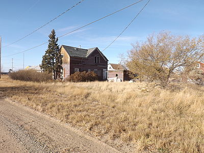 Deserted house

See also
[edit]References
[edit]- ^ a b c 91 Census (PDF). Population and Dwelling Counts. Vol. Unincorporated Places. Ottawa: Statistics Canada. 1993. Retrieved September 26, 2024.
- ^ "Specialized and Rural Municipalities and Their Communities" (PDF). Alberta Municipal Affairs. June 3, 2024. Retrieved June 14, 2024.
- ^ "Manyberries CDA, Alberta". Canadian Climate Normals 1971–2000 (in English and French). Environment Canada. Retrieved November 23, 2016.
- ^ "Onefour, Alberta". Canadian Climate Data (in English and French). Environment Canada. Retrieved November 23, 2016.
- ^ Ninth Census of Canada, 1951 (PDF). Vol. SP-7 (Population: Unincorporated villages and hamlets). Dominion Bureau of Statistics. March 31, 1954. Retrieved September 22, 2024.
- ^ Census of Canada, 1956 (PDF). Vol. Population of unincorporated villages and settlements. Dominion Bureau of Statistics. October 25, 1957. Retrieved September 23, 2024.
- ^ 1961 Census of Canada: Population (PDF). Series SP: Unincorporated Villages. Vol. Bulletin SP—4. Ottawa: Dominion Bureau of Statistics. April 18, 1963. Retrieved September 25, 2024.
- ^ Census of Canada 1966: Population (PDF). Special Bulletin: Unincorporated Places. Vol. Bulletin S–3. Ottawa: Dominion Bureau of Statistics. 1968. Retrieved September 25, 2024.
- ^ 1971 Census of Canada: Population (PDF). Special Bulletin: Unincorporated Settlements. Vol. Bulletin SP—1. Ottawa: Statistics Canada. 1973. Retrieved September 25, 2024.
- ^ "Geographical Identification and Population for Unincorporated Places of 25 persons and over, 1971 and 1976". 1976 Census of Canada (PDF). Supplementary Bulletins: Geographic and Demographic (Population of Unincorporated Places—Canada). Vol. Bulletin 8SG.1. Ottawa: Statistics Canada. 1978. Retrieved September 26, 2024.
- ^ 1981 Census of Canada (PDF). Place name reference list. Vol. Western provinces and the Territories. Ottawa: Statistics Canada. 1983. Retrieved September 26, 2024.
- ^ 1986 Census of Canada (PDF). Population. Vol. Unincorporated Places. Ottawa: Statistics Canada. 1988. Retrieved September 26, 2024.
Places adjacent to Manyberries | ||||||||||||||||
|---|---|---|---|---|---|---|---|---|---|---|---|---|---|---|---|---|
| ||||||||||||||||
| International | |
|---|---|
| National | |