
Reghaïa Valley
| Reghaia Valley | |
|---|---|
 | |
| Location | |
| Country | |
| Physical characteristics | |
| Source | Tell Atlas, Khachna, Boumerdès Province |
| • coordinates | 36°39′40″N 3°24′21″E / 36.6610778°N 3.4058266°E |
| • length | Boumerdès Province, Bouzegza Keddara, 500 Meter |
| 2nd source | Tell Atlas, Khachna, Boumerdès Province |
| • coordinates | 36°40′32″N 3°19′52″E / 36.6756751°N 3.3311396°E |
| • length | Boumerdès Province, Khemis El-Khechna, 472 Meter |
| Source confluence | Algiers Province,36°44′18″N 3°20′44″E / 36.738238°N 3.3456504°E |
| • elevation | Reghaïa, 72 Meter |
| Basin size | Drainage basin, 88 km2 (34 sq mi) |
| Basin features | |
| Landmarks | {[Flag|Algeria}}
Boumerdès Province Bouzegza Keddara, El Kharrouba, Ouled Moussa, Khemis El-Khechna, Ouled Hedadj Algiers Province Reghaïa, H'raoua |
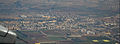
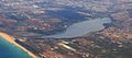
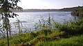
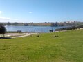
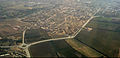
Reghaïa Valley is one of the rivers in the province of Algiers, extending 17.13 kilometers to the east of the Algerian capital. Its mouth is located between the municipalities of Reghaïa and H'raoua. It is among the longest and most water-abundant rivers in the Algiers region. The river originates in the Tell Atlas and the Khachna Mountains, near the municipality of Kedara in the Boumerdes province, flowing through Algiers before draining into Lake Reghaïa near the Réghaïa forest, and eventually emptying into the Mediterranean Sea.[1]
Description
[edit]The spring of Reghaïa Valley is located at Ben Ammar Valley in the municipality of Bouzegza Keddara, within the Khachna Mountains, at an elevation of 500 meters above sea level. The river is part of the Mediterranean basin.[2]
The course of Oued Reghaïa flows naturally downhill towards Réghaïa lake, where it branches off within the municipality of Reghaïa, forming three tributaries:
- Al-Abyar Valley
- Qasabya valley
- Gaqen Valley
Reghaïa Valley serves as a natural boundary between the municipalities of Reghaïa and H'raoua, creating an outlet through a drainage basin that covers an area of approximately 75 to 88 square kilometers and has a perimeter of around 42 kilometers.[3]
Geology
[edit]Reghaïa Valley site is located at the eastern geological boundary of the Mitidja syncline, a region formed by the emergence of elevations resulting from tectonic movements that brought volcanic rocks and smooth stones from the Tell Atlas, spreading across the entire Mitidja plain.
The coastal areas along the Mediterranean Sea feature a series of raised surfaces created by the withdrawal of seawater, leaving behind cohesive landforms.
The northern banks of the Reghaïa Valley exhibit a steep gradient. During the Pliocene epoch, erosion occurred along the riverbanks, leading to the formation of blue deposition rocks during the piacenzian stage.[4]
The sediments within the stream bed of the Reghaïa Valley are composed of fine gray sand, gravel, and pebble, with a thickness of several meters.[5]
Main source
[edit]Reghaïa Valley originates in the western part of the Bouzegza Keddara municipality within Boumerdes Province, approximately 14.34 kilometers (8.91 miles) in a straight line from its mouth at the Mediterranean Sea along the coast of Algiers Province. This source is situated within the Tell and Khachna Mountains, which lie between the provinces of Médéa, Bouira, Blida, and Boumerdes.[6]
The path
[edit]Reghaïa Valley runs through two coastal Algerian states.[7]
| Number | Boumerdès Province | Algiers Province |
|---|---|---|
| 01 | Bouzegza Keddara | Reghaïa |
| 02 | El Kharrouba | H'raoua |
| 03 | Ouled Moussa | |
| 04 | Khemis El-Khechna | |
| 04 | Ouled Hedadj |
Water bodies
[edit]The Reghaïa Valley intersects with several water bodies as it flows through the provinces of Algiers and Boumerdes in Algeria.
| Number | Boumerdès Province | Algiers Province |
|---|---|---|
| 01 | Keddara Dam | Réghaïa lake |
| 36°38′46″N 3°25′36″E / 36.6460971°N 3.4267111°E | 36°46′10″N 3°20′10″E / 36.7695421°N 3.3361168°E |
National roads
[edit]Reghaïa Valley crosses several national roads as it traverses through the provinces of Algiers and Boumerdes in Algeria.
| Number | Boumerdès Province | Algiers Province |
|---|---|---|
| 01 | National Road 29 | National Road 5 |
| 02 | National Road 5 | National Road No. 11 |
| 03 | National Road No. 11 | National Road No. 24 |
Train stations
[edit]
Reghaïa Valley intersects with several train stations as it flows through the region of Algiers and Boumerdes in Algeria.
| Number | Boumerdès Province | Algiers Province |
|---|---|---|
| 01 | Boudouaou train station | Raghaya train station |
River mouth
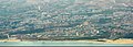
[edit]The mouth of the Reghaïa Valley is situated between the municipalities of Reghaïa and H'raoua in Algiers Province, near the "Soumam" neighborhood. The Valley serves as a boundary separating these two municipalities until it flows into the Mediterranean Sea along the coast of Algiers Province.[8]
River mouth location
[edit]The mouth of the Reghaïa Valley is located between the municipalities of Reghaïa and H'raoua, in proximity to the confluences of the Buduau Valley and El-Hamiz valley.[9] This picturesque site lies east of the El-Harrach Valley mouth and Sablons beach, making it a strategically location near the railway line connecting El-Harrach to Reghaïa.[10] The mouth of the Reghaïa Valley is approximately 26 kilometers east of the Casbah of Algiers and overlooks the Mediterranean Sea[11].[12][13][14][15][16][17][18][19][20]
Places adjacent to Reghaïa Valley | ||||||||||||||||
|---|---|---|---|---|---|---|---|---|---|---|---|---|---|---|---|---|
| ||||||||||||||||
Pollution
[edit]Reghaïa Valley is noted for pollution in its waters, particularly from dichlorodiphenyltrichloroethane (DDT), which has been detected at a concentration of 1,600 picograms per liter in marine sediments at the river's mouth. In addition to DDT, low concentrations of other chlorinated organic, insecticides, including lindane, heptachlor, aldrin, dieldrin, and endosulfan, have also been identified in the river. Measurements taken in 2004 indicated oxygen concentration values in the Reghaïa River that reflected minimum pollution thresholds, with a recorded level of 7 milligrams per liter at the riverbed. Moreover, the random dispersion of nitrates within the watercourse has led to an increased average concentration of 1.94 micrograms per liter.[21]
Neighboring bodies
[edit]-
-
-
-
-
-
 National Road No. 5 (Algiers)
 -
 National Road 24 (Algiers)


See also
[edit]Related topics
[edit]- List of rivers of Algeria
- Ministry of Water Resources and Environment
- Discharge regime
- Tell Atlas
- Khachna
- Mitidja
- Kabylia
- Igawawen
- Algiers Province
- Boumerdès Province
- Réghaïa forest
- Réghaïa lake
- List of beaches
- Tourism in Algeria
- Lists of tourist attractions
References
[edit]- ^ In the same way : The project to clean up the El Harrach Valley is part of the strategy to rehabilitate the city of Algiers Archived July 14, 2018, at the Wayback Machine.
- ^ https://web.archive.org/web/20160507223247/http://195.97.36.231/dbases/MAPlibraryHoldings/Medpartnership/FINAL%20REPORTS/Sub-Comp%201.2%20ICZM/1.2.2%20Demonstrations/Reghaia/Thematic%20reports%20_%20phase%201/Pollution%20hydrique_Chenit.pdf. Archived from the original (PDF) on 2016-05-07. : Medium |title=none or empty (help)
- ^ Caractèristiques physiques et morphologique - Agence de Promotion et de Protection du Littoral de la Wilaya d'Alger Archieved 28 April 2016 on Wayback machine.
- ^ Physical and morphological characteristics - Agence de Promotion et de Protection du Littoral de la Wilaya d'Alger Archieved 28 April 2016 on wayback machine.
- ^ https://web.archive.org/web/20181222234734/http://www.rac-spa.org/sites/default/files/doc_medmpanet/final_docs_algeria/12_bilan_diagnostic_rn_de_reghaia_algerie.pdf. Archived from the original (PDF) on 2018-12-22.
- ^ Google Maps Archived December 16, 2019, at the Wayback Machine.
- ^ Google Maps Archived December 16, 2019, at the Wayback Machine.
- ^ Google Maps Archived December 16, 2019, at the Wayback Machine.
- ^ Google Maps Archived July 20, 2019, at the Wayback Machine.
- ^ "TerraServer - Viewer Aerial Photos & Satellite Images - The Leader In Online Imagery". terraserver.com. Archived from the original on 2016-03-10. Accessed April 27, 2016. Archived March 10, 2016 at the Wayback Machine.
- ^ "Panoramio - Photos of the World". panoramio.com. Archived from the original on 2019-04-20. Accessed April 27, 2016. Archived January 19, 2014 at the Wayback Machine.
- ^ "Bing". bing.com. Archived from the original on 2023-04-02. Accessed April 27, 2016.
- ^ "Wikimapia - Let's describe the whole world!". wikimapia.org. Archived from the original on April 2, 2023. Accessed April 27, 2016.
- ^ http://services.arcgisonline.com/ArcGIS/rest/services/World_Imagery/MapServer/MapServer https://web.archive.org/web/20200103235441/http://www.arcgis.com/home/webmap/viewer.html?center=3.1434649,36.7348678&level=16&basemapUrl= http://services.arcgisonline.com/ArcGIS/rest/services/World_Imagery/MapServer/MapServer. Archived from the original http://services.arcgisonline.com/ArcGIS/rest/services/World_Imagery/MapServer/MapServer on 2020-01-03.
- ^ "OpenStreetMap". OpenStreetMap. Archived from the original on 2023-03-31. Accessed April 27, 2016.
- ^ "Flash Earth". flashearth.com. Archived from the original on 2023-04-02. Accessed April 27, 2016.
- ^ "Google Maps". google.dz. Archived from the original on 2023-04-02. Accessed on 2016-05-23.
- ^ "maps - Yahoo Search Results". yahoo.com. Archived from the original on 2023-04-02. Accessed April 27, 2016.
- ^ "ScanEx Web Geomixer - просмотр карты". kosmosnimki.ru. Archived from the original on 2022-06-27. Accessed April 27, 2016.
- ^ "HERE Maps - City and Country Maps - Driving Directions - Satellite Views - Routes". here.com. Archived from the original on 2023-04-02. Accessed April 27, 2016.
- ^ https://web.archive.org/web/20160704233519/http://www.appl.dz/download/pollution_lac_reghaia_ismal_2005.pdf. Archived from the original (PDF) on July 4, 2016. Accessed August 2020.
External links
[edit]- Reghaia Valley and Lake on YouTube.
- Lake Raghaya on YouTube.
- Raghaya Beach on YouTube.
- Hajra Bontah in Raghaya Bay on YouTube.
- Raghaya Beach on YouTube.