Columbus originated as numerous Native American settlements on the banks of the Scioto River. Franklinton, now a city neighborhood, was the first European settlement, laid out in 1797. The city was founded in 1812 at the confluence of the Scioto and Olentangy rivers, and laid out to become the state capital. The city was named for Italian explorer Christopher Columbus. The city assumed the function of state capital in 1816 and county seat in 1824. Amid steady years of growth and industrialization, the city has experienced numerous floods and recessions. Beginning in the 1950s, Columbus began to experience significant growth; it became the largest city in Ohio in land and population by the early 1990s. Growth has continued in the 21st century, with redevelopment occurring in numerous city neighborhoods, including Downtown. (Full article...)
Historic Crew Stadium, previously known as Columbus Crew Stadium and Mapfre Stadium, is a soccer-specific stadium in Columbus, Ohio, United States. It primarily served as the home stadium of the Columbus Crew of Major League Soccer from 1999 until 2021, when the team moved to Lower.com Field. Historic Crew Stadium is the current home of the Crew's training facility, the OhioHealth Performance Center and MLS Next Pro team Columbus Crew 2. Historic Crew Stadium is also the site of a variety of additional events in amateur and professional soccer, American football, lacrosse, and rugby, and is a regular site for outdoor concerts due to the permanent stage in the north end zone.
Built in 1999, it was the first soccer-specific stadium built by a Major League Soccer team, starting an important trend in MLS stadium construction. The stadium was named for Madrid-based Mapfre Insurance after the company signed a 5-year sponsorship agreement announced on March 3, 2015. In December 2020, the deal expired and the Crew renamed the stadium. The listed seating capacity is 19,968. In 2015, Mapfre Stadium and Director of Grounds Weston Appelfeller were honored with the prestigious Field of the Year award by the Sports Turf Managers Association (STMA) for the professional soccer division. (Full article...)
Image 2
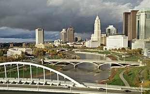
Skyline of Columbus (Use cursor to identify buildings)The tallest building by height in the U.S. city of Columbus, Ohio, is the 41-storyRhodes State Office Tower, which rises 629 feet (192 m) and was completed in 1973. The structure is the fifth-tallest completed building in the state, and is also Ohio's tallest building that rises in the center of a city block. The city's second-tallest structure is the LeVeque Tower; this 1927 Art Deco skyscraper was the first building in the state to be built on caisson foundations. Of the 20 tallest buildings in Ohio, nine are located in Columbus.
The history of skyscrapers in Columbus began with the completion in 1901 of 16 East Broad Street, which is regarded as the first high-rise in the city. This structure stands 13 stories and 180 feet (55 m) in height. Columbus went through an early high-rise construction boom in the 1920s, during which time the city saw the completion of the 555-foot (169 m) LeVeque Tower, which stood as the tallest structure in Columbus for 46 years. However, the pace of new high-rise construction then remained slow until 1960; starting in that year, Columbus entered into a large building boom that lasted until 1991. During that time, most of the city's tallest skyscrapers were built, including the Rhodes State Office Tower and the William Green Building. Although no Columbus skyscraper ranks among the tallest in the United States, the city is the site of five skyscrapers at least 492 feet (150 m) high. Based on existing and under-construction buildings over 500 feet (152 m) tall, the skyline of Columbus is tied with Cleveland for first in Ohio, fourth in the Midwest (after Chicago, Minneapolis, and Detroit) and 19th in the country.[A] As of June 2023, there are 114 completed high-rises in the city. Columbus ranks third in the state in high-rise count after Cleveland and Cincinnati, which have 163 and 169 completed high-rises respectively. (Full article...)
Image 3
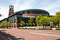
COSI (/ˈkoʊsaɪ/), officially the Center of Science and Industry, is a science museum and research center in Columbus, Ohio. COSI was opened to the public on 29 March 1964 and remained there for 35 years. In 1999, COSI was moved to a 320,000-square-foot (30,000 m2) facility, designed by Japanese architect Arata Isozaki along a bend in the Scioto River in the Franklinton neighborhood. COSI features more than 300 interactive exhibits throughout themed exhibition areas.
Until the COVID-19 pandemic, COSI operated the largest outreach education program of any science museum in the United States. Anchored by COSI on Wheels – a whole-school outreach program traveling throughout Ohio and the surrounding Midwest – as well as local COSI on Wheels Workshops, Camp COSI on Wheels, and Interactive Videoconference programs reaching 350,000 learners each year outside of the museum at their peak.
As a non-profit organization, COSI is supported by ticket sales, a network of community and statewide partnerships (including relationships with a variety of donors and sponsors), a volunteer program supported by 10,000 volunteers annually, and nearly 20,000 member households. In 2008, COSI was named the #1 science center in the United States for families by Parent Magazine. In 2020, it was named the #1 Science Museum in the United States by USA Today. (Full article...)
Image 4
Broad Street over the Discovery Bridge heading east into downtown
Broad Street was first laid out around 1797, when Franklinton was settled. In 1812, when Columbus was founded, a new section of the street was built in the new city. The street first connected to the rest of the settled country in 1831, when the Ohio and Erie Canal reached Columbus. In 1833, the National Road was extended to Columbus, utilizing all of West Broad Street. In the mid-to-late 19th century, East Broad Street became a fashionable place for wealthy homeowners, and large mansions were built along the tree-lined street. Large hotels and apartments followed into the early 1900s. The street has seen numerous changes since then, including clearing and widening. Portions of the street were improved with trees, bike lanes, and rainwater basins in Franklinton, with additional streetscape improvements planned for other sections of the street. (Full article...)
Image 5
Riverbend is a neighborhood in southwest Columbus, Ohio. Riverbend itself is a single subdivision that is located next to Big Run Park. Because Riverbend is at the southwest border of the city, it was not annexed into the city until the late 1960s. A major road that serves as the northern boundary of the neighborhood, Clime Road, has segments that have yet to be annexed into the city. (Full article...)
Ohio History Connection, formerly The Ohio State Archaeological and Historical Society and Ohio Historical Society, is a nonprofit organization incorporated in 1885. Headquartered at the Ohio History Center in Columbus, Ohio, Ohio History Connection provides services to both preserve and share Ohio's history, including its prehistory, and manages over 50 museums and sites across the state. An early iteration of the organization was founded by Brigadier GeneralRoeliff Brinkerhoff in 1875. Over its history, the organization changed its name twice, with the first occurring in 1954 when the name was shortened to Ohio Historical Society. In 2014, it was changed again to Ohio History Connection, in what members believed was a more modern and welcoming representation of the organization's image. (Full article...)
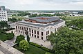
The Main Library of the Columbus Metropolitan Library (CML) system is located in Downtown Columbus, Ohio, United States. The public library is the largest in the library system and holds approximately 300,000 volumes. It includes numerous rooms, including separate spaces for children, teens, an adult reading room, newspaper room, auditorium, gallery, gift shop, and a cafe. The third floor includes a computer lab and houses the Franklin County Genealogical & Historical Society.
The library building was proposed as early as 1901 when the public used a reading room in Columbus's city hall. In 1903, Andrew Carnegie largely funded its construction, making it a Carnegie library. The library was designed by Albert Randolph Ross in the Beaux-Arts style, using white Vermont marble. The building opened in 1907. It was first expanded in 1953 and 1961, followed by a 1991 addition and the demolition of the two prior structures; the process tripled the building's size. In 2015 and 2016, another renovation took place to increase reader space, add to its west lawn, join the building to Topiary Park at its east, and clad most of the 1991 building in glass. (Full article...)
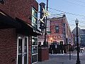
KEMBA Live! (originally the PromoWest Pavilion) is a multi-purpose concert venue located in the Arena District of Columbus, Ohio. Opening in 2001, the venues operates year-round with indoor and outdoor facilities: the Indoor Music Hall and Outdoor Amphitheater. The venue was modeled after the House of Blues and described as the "Newport Music Hall on steroids". It features state-of-the-art lighting, acoustical systems and a reversible stage. In 2001, the venue was nominated for a Pollstar Awards for "Best New Major Concert Venue".
A sister venue, Stage AE is located in Pittsburgh, Pennsylvania and opened in December 2010. In 2018, Promowest Productions and its venues were acquired by American entertainment presenter AEG. In August 2021, PromoWest Productions and AEG opened another sister venue, MegaCorp Pavilion, in Newport, Kentucky (near Cincinnati, Ohio). (Full article...)
Image 13
The Columbus Quest was a professional women's basketball franchise located in Columbus, Ohio, in the now-defunct American Basketball League (ABL). They were one of the league's original eight teams that started play in 1996. In the league's brief history, the Quest was its most successful franchise, winning both championships the league awarded.
The Quest's head coach was Brian Agler, who finished with a record of 82–22 during the team's two-plus seasons of existence. After Agler left the Quest midseason to become the head coach of the WNBA's Minnesota Lynx, the team was coached by player-coach Tonya Edwards . Many of the Quest's players later played for the Lynx, including Edwards, Katie Smith, Andrea Lloyd-Curry, Angie Potthoff and Shanele Stires.
The Quest played their home games at the Greater Columbus Convention Center in Battelle Hall. Despite being the league's most successful team, they had the league's lowest average attendance for all three years of the ABL's existence. (Full article...)
Image 14
Milo-Grogan is a neighborhood of Columbus, Ohio. The neighborhood was settled as the separate communities of Milo and Grogan in the late 1870s. Large-scale industrial development fueled the neighborhood's growth until the 1980s, when the last factories closed. The community has received urban renewal efforts in recent years fueled by the Columbus Department of Development and Milo-Grogan Area Commission. (Full article...)
Mill Street after the flood, with the tower of Engine House No. 6 in the background
The Great Flood of 1913 severely affected Columbus, Ohio. The area most affected was Franklinton, also known as the Bottoms, for its low elevation near the Scioto River. Among many infrastructure projects, a 7.2-mile floodwall was built from 1993 to 2004 to protect most of Franklinton from flooding.
Columbus historian Ed Lentz described the 1913 flood as "the worst catastrophe in the history of Columbus". (Full article...)
Image 17
Ohio State School for the Blind (OSSB or OSB) is a school located in Columbus, Ohio, United States. It is run by the Ohio Department of Education for blind and visually impaired students across Ohio. It was established in 1837, making it the nation's first public school for the visually impaired. The Ohio Institution for the Education of the Blind building was constructed in 1874 in downtown Columbus on Parsons Ave. Later it became the headquarters for the Ohio State Highway Patrol, and is now home to the Columbus Public Health offices. In the early 1900s, the Ohio Institution for the Education of the Blind became known as the Ohio State School for the Blind. In the mid-1950s the school moved to its current location at 5220 N. High St on the ground of a defaulted golf course. Over its history, the school has seen a vast change in its population and demographics, originally housing a majority of single disability student to now educating students with a variety of abilities.
In the basement of the school sits a vast collection of models that were constructed and purchased over time, of various monuments around the United States that blind students may not be able to see with their eyes but instead could examine with their hands. While the majority of the models were constructed of quality material, there are some that have been neglected and damaged over the years. And have such been repaired and sit in the lobby of the newly built building. (Full article...)
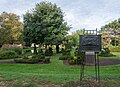
Glen Echo is a neighborhood located in the far northern part of the University District in Columbus, Ohio. The area was listed on the National Register of Historic Places in 1997. The name Glen Echo refers to Glen Echo Ravine, which runs along the northern edge of the neighborhood. Principal streets in the area are Glen Echo Drive, Summit Street, Glenmawr Avenue, North Fourth Street, Arcadia, Cliffside Drive, and more. One street, Parkview Drive, was platted in the ravine basin, but was later abandoned.
The district originated in 1909 when the Columbus Real Estate and Improvement Company platted 47 acres (19 ha) as "Indianola Park View" for a planned residential subdivision and a part of the Glen Echo Ravine was delineated as a park, the first such donation to the city of Columbus by a real estate developer. The wooded Glen Echo Ravine significantly influenced the original layout, design, and overall character of the district. The neighborhood's developer was also involved with the development of Walhalla Ravine and Eastgate. Prior to its development, the area was considered for a major hospital; however, those plans were abandoned.
A 1909 Ohio State publication described the new north side park as a place of beauty where large oak and elm trees shaded a wading pond, five small lakes connected by a single stream, rustic benches, foot bridges and springs lined with cobblestones. Glen Echo's picturesque environs hosted picnic dinners, equestrians and motorists who enjoyed this oasis of greenery. In 1910 the development was annexed to the City of Columbus and in 1912 Glen Echo Park was dedicated to the city. (Full article...)
Following a local version of the City Beautiful movement, the Columbus Plan first envisioned a riverfront civic center in 1908. The Great Flood of 1913 destroyed many riverfront structures, allowing the opportunity to redevelop according to the 1908 plan. Columbus's most prominent architect, Frank Packard, spearheaded the project until his unexpected death in 1923. The Neoclassical, Renaissance Revival, and Art Deco buildings, bridges, and retaining wall were built from 1917 to 1934. In 1988, the area was nominated to the National Register of Historic Places as the Columbus Civic Center Historic District. (Full article...)
The museum, opened in 2002, is a 24,000-square-foot (2,200 m2) facility offering a comprehensive view of Nicklaus' life and career in and out of golf as well as exhibits celebrating the history and legends of the game. In 2005, it was transferred by the private Jack Nicklaus Museum Inc. to Ohio State University.
It houses three theaters, a golf shop and a number of exhibit galleries. (Full article...)
Image 22
Houses in Minerva Park, a village in the Northland area
Northland is a residential and commercial area in northeast Columbus, Ohio. The area is served by the Northland Community Council, which oversees land east of Worthington, roughly north of Morse Road, south of I-270, and west of New Albany, including the neighborhood Forest Park and the independent village of Minerva Park.
The area has one of the largest populations of new American citizens in Columbus, including thousands of refugees from Nepal, Somalia, and Bhutan. (Full article...)
On February 7, 2019, the AFL announced that it had placed an expansion team in Columbus and once again play at Nationwide Arena. The league announced on February 22, 2019, that the team as a re-launch of the Destroyers and revealed the new logo and Matthew Sauk as the head coach.
After the 2019 season, the AFL announced that they had suspended local business operations including the Destroyers, but were looking into become a traveling league. A month later, on November 27, 2019, the league announced that they had filed for Chapter 7 bankruptcy and were ceasing operations. (Full article...)
Image 24
Interactive map highlighting the main building's location
Columbus Public Health is the health department of Columbus, Ohio. The department is accredited by the Public Health Accreditation Board. The department dates to 1833, when the city's mayor appointed five citizens to help with its cholera outbreak. It became a permanent body to activate whenever health emergencies arose.
Driving Park is an urban residential area on the Near East Side of Columbus, Ohio just south of Interstate 70. Mainly a middle-class, predominantly African American neighborhood, Driving Park and its surrounding neighborhoods consist of an area of 17,730 residents. Driving Park received its name from its historic past as a large racing complex, first for horses and later for automobiles. (Full article...)
Need help?
Do you have a question about Columbus, Ohio that you can't find the answer to?
Image 62010 Census-based map: red dots indicate white Americans, blue dots for African Americans, green for Asian Americans, orange for Hispanic Americans, yellow for other races. Each dot represents 25 residents. (from Neighborhoods in Columbus, Ohio)
Image 30Map of the Ohio Country between 1775 and 1794, depicting locations of battles and massacres surrounding the area that would eventually become the U.S. state of Ohio (from Columbus, Ohio)
Image 69Map of the Ohio Country between 1775 and 1794, depicting locations of battles and massacres surrounding the area that would eventually become Ohio (from History of Columbus, Ohio)


.jpg)


 The city in 1936 (from Columbus, Ohio)
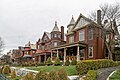 Victorian houses facing Goodale Park in Victorian Village (from Columbus, Ohio)
 2010 Census-based map: red dots indicate white Americans, blue dots for African Americans, green for Asian Americans, orange for Hispanic Americans, yellow for other races. Each dot represents 25 residents. (from Neighborhoods in Columbus, Ohio)
 Homes in German Village (from Neighborhoods in Columbus, Ohio)
 The Art Deco LeVeque Tower is the city's second-tallest skyscraper. (from Columbus, Ohio)
 View of the city from Capital University in 1854 (from Columbus, Ohio)
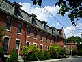 Italian Village rowhouse (from Neighborhoods in Columbus, Ohio)
 Map of land surveys and city boundary growth, 1812–1920 (from History of Columbus, Ohio)
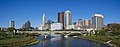 Panorama of downtown Columbus from the Main Street Bridge (from Columbus, Ohio)
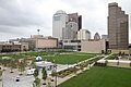

 Barlouie (from Neighborhoods in Columbus, Ohio)
 Brewery District Scene (from Neighborhoods in Columbus, Ohio)
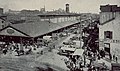 Central Market, pictured here in 1898, operated from 1814 to 1966. (from Columbus, Ohio)
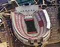 Ohio Stadium, on the campus of Ohio State University, is the 5th-largest non-racing stadium in the world. (from Columbus, Ohio)
 Bird's eye view map of Columbus in 1872 (from Columbus, Ohio)
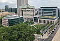 Municipal offices, including the Columbus Division of Police Headquarters, in the city's Civic Center (from Columbus, Ohio)
 Camp Chase as it stands today, a memorial to fallen soldiers from the American Civil War. (from Neighborhoods in Columbus, Ohio)
 Arcade of the third Union Station, the city's rail station from 1897 to 1977 (from Columbus, Ohio)
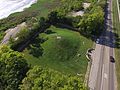 Shrum Mound, the feature of Campbell Memorial Park (from History of Columbus, Ohio)
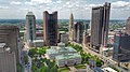 Four of the city's five tallest buildings are around Capitol Square (from List of tallest buildings in Columbus, Ohio)
 Eastern side of Olentangy Commons (from Neighborhoods in Columbus, Ohio)
 Map of the Ohio Country between 1775 and 1794, depicting locations of battles and massacres surrounding the area that would eventually become the U.S. state of Ohio (from Columbus, Ohio)
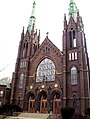 Holy Rosary and Saint John Church (from Neighborhoods in Columbus, Ohio)
 Hungarian Reform Church, in Hungarian Village (from Neighborhoods in Columbus, Ohio)
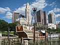 The Santa Maria Ship & Museum, a Santa María replica, was docked downtown from 1991 to 2014. (from Columbus, Ohio)
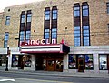 The historic Lincoln Theatre (from Neighborhoods in Columbus, Ohio)
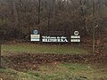 Hilltop signage (from Neighborhoods in Columbus, Ohio)
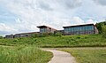 Audubon nature center at Scioto Audubon Metro Park, the first built close to a major city's downtown (from Columbus, Ohio)
 Skyline of Columbus (Use cursor to identify buildings) (from List of tallest buildings in Columbus, Ohio)
 Aerial satellite image of Columbus (from Columbus, Ohio)
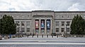 COSI (east entrance pictured) features themed, interactive science exhibits. (from Columbus, Ohio)
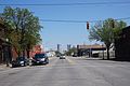 West Broad Street in Franklinton (from Neighborhoods in Columbus, Ohio)
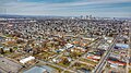 Aerial view of Reeb-Hosack (from Neighborhoods in Columbus, Ohio)
 Port Columbus Airport tower and terminal from 1929 to 1958 (from Columbus, Ohio)
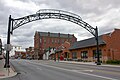 Old North Columbus Arch (from Neighborhoods in Columbus, Ohio)
 The Merion Village arch (from Neighborhoods in Columbus, Ohio)
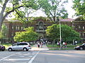 Indianola Junior High School was the first middle school in the U.S. (from Columbus, Ohio)
 The Discovery Bridge (from Columbus, Ohio)
 Home in Old Oaks (from Neighborhoods in Columbus, Ohio)
 The city c. 1924 (from History of Columbus, Ohio)
 John Glenn Columbus International Airport departure level (from Columbus, Ohio)
 Located in the Arena District, McFerson Commons is home to the Union Station arch. (from Columbus, Ohio)
 Columbus City Hall (from Columbus, Ohio)
 Big Run Sports Complex, in Big Run Park (from Neighborhoods in Columbus, Ohio)
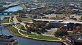 The Scioto Mile includes nine parks along both banks of the Scioto River between downtown Columbus and Franklinton. (from Columbus, Ohio)
 The Columbus Museum of Art collects and exhibits American and European modern and contemporary art, folk art, glass art, and photography. (from Columbus, Ohio)
 Historic Home in Harrison West (from Neighborhoods in Columbus, Ohio)
 The Ohio State Fair is held in late July to early August. (from Columbus, Ohio)
 Dutch Colonial Style residences in Hungarian Village (from Neighborhoods in Columbus, Ohio)
 Taylor House on Bethel Rd. (from Neighborhoods in Columbus, Ohio)
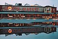 North Market (from Columbus, Ohio)
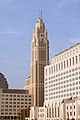 The LeVeque Tower was the tallest building in Columbus from 1927 to 1973. (from List of tallest buildings in Columbus, Ohio)
 COTA's Spring Street Terminal, one of its five transit centers (from Columbus, Ohio)
 Locations of numbered streets and avenues (from Columbus, Ohio)
 The Pontifical College Josephinum (1888-1931) (from List of demolished buildings and structures in Columbus, Ohio)
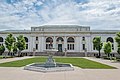
 1954 urban renewal map of Columbus (from List of demolished buildings and structures in Columbus, Ohio)
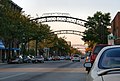 The iconic arches of the Short North (from Neighborhoods in Columbus, Ohio)
 Street arches returned to the Short North in late 2002. (from History of Columbus, Ohio)
 St. Mary Magdalene Church in Westgate (from Neighborhoods in Columbus, Ohio)
 Lou Berliner Sports Park (from List of parks in Columbus, Ohio)
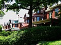 Victorian-style homes located along Goodale Park (from Neighborhoods in Columbus, Ohio)

.jpg)


.png)


.jpg)


.jpg)
.jpg)


.jpg)


_crop.jpg)


_-_exterior_2.jpg)


 Commons
 Wikibooks
 Wikidata
 Wikinews
 Wikiquote
 Wikisource
 Wikiversity
 Wiktionary