
User:Gazamp/Safekeeping
| {{{1}}} |
|2=
|2=

The Andes (/ˈændiːz/ AN-deez), Andes Mountains or Andean Mountain Range (Spanish: Cordillera de los Andes; Quechua: Anti) are the longest continental mountain range in the world, forming a continuous highland along the western edge of South America. The range is 8,900 km (5,530 mi) long and 200 to 700 km (124 to 435 mi) wide (widest between 18°S and 20°S latitude) and has an average height of about 4,000 m (13,123 ft). The Andes extend from South to North through seven South American countries: Argentina, Chile, Bolivia, Peru, Ecuador, Colombia, and Venezuela.
Along their length, the Andes are split into several ranges, separated by intermediate depressions. The Andes are the location of several high plateaus—some of which host major cities such as Quito, Bogotá, Cali, Arequipa, Medellín, Bucaramanga, Sucre, Mérida, El Alto, and La Paz. The Altiplano Plateau is the world's second highest after the Tibetan Plateau. These ranges are in turn grouped into three major divisions based on climate: the Tropical Andes, the Dry Andes, and the Wet Andes. (Full article...)
Selected general articles
-

The hooded mountain tanager (Buthraupis montana) is a species of bird in the tanager family Thraupidae. It is the only member of the genus Buthraupis. This yellow, blue and black tanager is found in forest, woodland and shrub in the Andean highlands of Bolivia, Colombia, Ecuador, Peru, and Venezuela. At 23 centimetres (9.1 in) and 85 grams (3.0 oz), it is one of the largest tanagers (second in weight only to the white-capped tanager). (Full article...) -

The Titicaca grebe (Rollandia microptera), also known as the Titicaca flightless grebe or short-winged grebe, is a grebe found on the altiplano of Peru and Bolivia. As its name implies, its main population occurs on Lake Titicaca. Lake Uru Uru and Poopó, the Rio Desaguadero, and small lakes that connect to Lake Titicaca in wet years, serve as "spillovers" territory. In the past, the population was larger and several of these lakes – such as Lakes Umayo and Arapa – apparently had and may still have permanent large colonies (BirdLife International 2006). It is sometimes placed in Podiceps or a monotypic genus Centropelma. Its local name is zampullín del Titicaca. (Full article...) -
Nevado del Huila (/nɛˈvɑːdoʊ dɛl ˈwiːlə/, Spanish pronunciation: [neˈβaðo ðel ˈwila]) at 5,364 metres (17,598 ft), is the highest volcano in Colombia, located at the tripoint of the departments of Huila, Tolima and Cauca. It is visible from the city of Cali. The andesitic volcano is located on top of the Ibagué Batholith.
After being dormant for more than 500 years, the volcano showed heavy signs of activity in 2007 and 2008. As of February 20, 2007, there were more than 7000 "minor" seismic events, and a high state of alert was in place for the departments of Cauca, Huila, Caldas and Valle del Cauca. The volcano erupted twice in April 2007, once in April 2008 and again in November 2008. Any eruption would affect the small villages around the volcano, mostly Páez, where their inhabitants still have in memory the eruption of the Nevado del Ruiz volcano and the destruction of Armero. (Full article...) -
Rasac (possibly Quechua for toad) is a mountain in the Huayhuash mountain range in west central Peru, part of the Andes. It has a summit elevation of 6,017 metres (19,741 ft), although other sources cite a height of 6,040 metres (19,816 ft). Rasac is a long, relatively squat mountain on the western edge of the Huayhuash range, across the glacier from the tallest peak in the range, Yerupajá. Although it is a 6,000 metre mountain, Rasac's broad profile is dwarfed by Yerupajá. (Full article...) -

Andean Geology (formerly Revista Geológica de Chile) is a peer-reviewed scientific journal published three times per year by the National Geology and Mining Service, Chile's geology and mining agency. The journal covers the field of geology and related earth sciences, primarily on issues that are relevant to South America, Central America, and Antarctica with a particular focus on the Andes. The journal was established in 1974 and articles are published in English and Spanish. The editor-in-chief is Waldo Vivallo (National Geology and Mining Service). (Full article...) -
Pico Bolívar is the highest mountain in Venezuela, at 4,978 metres (16,332 ft). Located in Mérida State. It can be reached only by walking; the Mérida cable car, which was the highest and longest cable car in the world when it was built, only reaches Pico Espejo. From there it is possible to climb to Pico Bolívar. The peak is named after the Venezuelan independence hero Simón Bolívar.
The Pico Bolívar is located on the mountain previously called La Columna, next to El León (4,743 m) and El Toro (4,695 m). The new name was suggested by Tulio Febres Cordero in 1925. It was officially renamed on December 30, 1934. (Full article...) -
Cerro Galán is a caldera in the Catamarca Province of Argentina. It is one of the largest exposed calderas in the world and forms part of the Central Volcanic Zone of the Andes, one of the three volcanic belts found in South America. One of several major caldera systems in the Central Volcanic Zone, the mountain is grouped into the Altiplano–Puna volcanic complex.
Volcanic activity at Galán is the indirect consequence of the subduction of the Nazca Plate beneath the South America Plate, and involves the infiltration of melts into the crust and the formation of secondary magmas which after storage in the crust give rise to the dacitic to rhyodacitic rocks erupted by the volcano. (Full article...) -
The Sierra de La Culata is a mountain range in the largest massif in Venezuela, the Cordillera de Mérida, which in turn is part of the northern extent of the Cordillera de los Andes (Andes Mountains). The Sierra la Culata includes some of the highest peaks in Venezuela, such as Pico Piedras Blancas, Pico Pan de Azúcar, and Collado del Cóndor.
It is located between the states of Mérida and Trujillo. Most of the lagoons are a result of the Mérida glaciation. (Full article...) -
The Tropical Andes is northern of the three climate-delineated parts of the Andes, the others being the Dry Andes and the Wet Andes. The Tropical Andes' area spans 1,542,644 km2 (595,618 sq mi). (Full article...) -
Mount Darwin (Spanish: Monte Darwin) is a peak in Isla Grande de Tierra del Fuego forming part of the Cordillera Darwin, the southernmost range of the Andes, just to the north of the Beagle Channel. It is 2,438 m (7,999 ft) high.
Monte Darwin was for a long time considered as the highest peak in Tierra del Fuego, but that distinction corresponds to a nearby mountain unofficially named Monte Shipton (also somewhat confusingly referred to as Darwin or Agostini-Darwin), which is about 2,580 m (8,460 ft) high and is located at . Both peaks are best climbed in late December, January, February and March. Monte Shipton was first climbed in 1962 by Eric Shipton, E. Garcia, F. Vivanco and C. Marangunic. (Full article...) -

The Andean flicker (Colaptes rupicola) is a species of bird in subfamily Picinae of the woodpecker family Picidae. It is found in Argentina, Bolivia, Chile, Ecuador, and Peru. (Full article...) -
The Nevado del Quindío, also known as Volcán Paramillo del Quindío or simply Paramillo del Quindío, is an inactive volcano located in the Central Cordillera of the Andes in central Colombia. The summit marks the tripoint of the departments of Risaralda, Tolima, and Quindío, and is the highest point of the latter. The mountain is the fourth highest peak in Los Nevados National Natural Park among those with a topographic prominence exceeding 300 meters. There are no historical records of any eruption. The andesitic volcano is located on top of the Palestina Fault.
The mountain formerly had glaciers, which disappeared in the second half of the 20th century due to changing climatic conditions associated with global warming. Presently there is no permanent ice, only intermittent snow. The mountain's alternative designation as "paramillo" (like paramo, a high-elevation area of sparse vegetation exposed to wind, rain, and cold) reflects this new reality, whereas the term "nevado" inaccurately implies continuous snow cover. (Full article...) -
Nevado Tres Cruces is a massif of volcanic origin in the Andes Mountains on the border of Argentina and Chile. It has two main summits, Tres Cruces Sur at 6,748 metres (22,139 ft) and Tres Cruces Centro at 6,629 m (21,749 ft) and a third minor summit, Tres Cruces Norte 6,030 m (19,780 ft). Tres Cruces Sur is the sixth highest mountain in the Andes.
The volcano has an extended history of activity, going back at least 1.5 million years. A number of lava domes surround the complex and a number of craters lie on its summits. The main volcano is of rhyodacitic composition and has generated two major ignimbritic eruptions, one 1.5 million years ago and a second 67,000 years ago. The last eruption was 28,000 years ago, but the volcano is a candidate source for a Holocene eruption and could erupt again in the future. (Full article...) -
Socompa is a large stratovolcano at the border of Argentina and Chile with an elevation of 6,051 metres (19,852 ft) metres. Part of the Chilean and Argentine Andean Volcanic Belt (AVB), it is within the Central Volcanic Zone, one of the various segments of the AVB. This part of the Andean volcanic belt begins in Peru and runs first through Bolivia and Chile, and then through Argentina and Chile, and contains about 44 active volcanoes. Socompa lies close to the pass of the same name, where the Salta-Antofagasta railway crosses the border.
Socompa is known for its large debris avalanche, which was formed 7,200 years ago when most of the northwestern slope collapsed and slid down, forming an extensive deposit. It was at first considered to be either a moraine or a nuee ardende deposit, until the 1980 eruption of Mount St. Helens prompted awareness of the instability of volcanic edifices and the existence of large scale collapses on them. The Socompa collapse is among the largest known with a volume of 19.2 cubic kilometres (4.6 cu mi) and covers a surface area of 490 square kilometres (190 sq mi), and its features are well preserved by the arid climate. Notable are the large toreva blocks which were left behind within the collapse crater. After the landslide, the volcano was rebuilt by the effusion of lava flows and much of the scar is now filled in. (Full article...) -

The guanaco (/ɡwɑːˈnɑːkoʊ/ ghwuah-NAH-koh; Lama guanicoe) is a camelid native to South America, closely related to the llama. Guanacos are one of two wild South American camelids; the other species is the vicuña, which lives at higher elevations. (Full article...) -
Wayna Potosí (Aymara and Quechua wayna young, Hispanicized spelling Huayna Potosí) is a mountain in the Andes of Bolivia, about 4,969 metres (16,302 ft) high. It is located in the Oruro Department, Sajama Province, Turku Municipality, Turku Canton, northwest of Turku (Turco). The Turku River originates near the mountain. It is a left tributary of the Lauca River. (Full article...)
-
Lake Mitococha or Mitucocha (possibly from Quechua mit'u, mitu mud, qucha lake, "mud lake") is a lake in Peru located in Huanuco Region, Lauricocha Province, Queropalca District. It has an elevation of 4,270 metres (14,009 ft) above sea level. It lies on the east side of the Huayhuash mountain range, northeast of Mituraju and Rondoy. Lake Mitococha is 0.83 km long and 0.3 km at its widest point. (Full article...) -
Monte San Valentin, also known as Monte San Clemente, is the highest mountain in Chilean Patagonia and the highest mountain south of 37°S outside Antarctica. It stands at the north end of the North Patagonian Icefield.
Monte San Valentin can be climbed from Lago Leones, to the south east, or from Laguna San Rafael, to the west. The ascent is long and is particularly subject to bad weather. (Full article...) -
The Wet Andes (Spanish: Andes húmedos) is a climatic and glaciological subregion of the Andes. Together with the Dry Andes it is one of the two subregions of the Argentine and Chilean Andes. The Wet Andes runs from a latitude of 35°S to Cape Horn at 56°S. According to Luis Lliboutry the Wet Andes can be classified after the absence of penitentes. In Argentina well developed penitentes are found as south as on Lanín Volcano (40°S). Another difference is that the Wet Andes is largely devoid of rock glaciers. The glaciers of the Wet Andes have a far more stable line of equilibrium than those of the Dry Andes due to summer precipitations, low thermal oscillations and an overall high moisture. (Full article...) -
Azufral is a stratovolcano located in the department of Nariño in southern Colombia, 12 km (7 mi) west of the town of Túquerres. It is the only volcano of the Western Ranges of the Colombian Andes. Its name derives from the Spanish word for sulfur, azufre. The volcano is considered semi-dormant but there are numerous fumaroles in the summit crater. The summit of the volcano has an altitude of 4,070 metres (13,350 ft), and the north-western side of the crater contains a crescent-shaped lake named Laguna Verde (English: Green Lake) at 3,970 m (13,025 ft). The lake is 1,100 m (0.68 mi) long and 600 metres (2,000 ft) wide. and its bright green color is a result of the sulfur and iron-based deposits in the crater. There are also two other much smaller lakes in the crater, Laguna Negra (English: Black Lake) and Laguna Cristal (English: Crystal Lake).
The volcano lies within a nature reserve, the Reserva Natural del Azufral, created in 1990. The reserve covers an area of 5,800 hectares (58 km2) and is free of charge to enter. As Azufral is semi-dormant, there are no restrictions on ascending the volcano and visiting Laguna Verde: there is a road that climbs to within 1.5 kilometers (1 mi) from the summit, and the remaining distance can be covered on foot via a trail. (Full article...) -

The Titicaca orestias, Lake Titicaca orestias, or Lake Titicaca flat-headed fish (Orestias cuvieri), also known by its native name amanto, is a likely extinct freshwater killifish from Lake Titicaca in South America. It belongs in the pupfish genus Orestias, endemic to lakes, rivers and streams in the Andean highlands. With a total length of up to 27 cm (10.6 in), it was the largest member in that genus. In the hope that an undiscovered population remains, it is listed as Data Deficient by the IUCN. Despite its common name, it is not the only Orestias from Lake Titicaca.
Its mouth was nearly turned upwards, thereby giving the flat head a concave shape. The head took up nearly a third of the whole body length. The upperside was greenish-yellow to umber. The lower jaw was black. Its scales were oddly light coloured at their centre. The scales of the young were blotched. (Full article...) -
The Pico Pan de Azúcar, at 4680 meters above sea level, is the ninth highest mountain of Venezuela, and the third highest of the Sierra de la Culata range in the Mérida State. Its name, which translates as "Bread of Sugar", is due to the sandy slopes of the mountain, which resembles "Pan dulce", a kind of bread sprinkled with sugar eaten in the country. The summit offers a scenic view, including Lake Maracaibo, Sierra Nevada de Mérida and the surrounding mountains of the Sierra de la Culata. (Full article...)
-
Pico Humboldt is Venezuela's second highest peak, at 4,925 metres above sea level. It is located in the Sierra Nevada de Merida, in the Venezuelan Andes of (Mérida State). The peak, its sister peak Pico Bonpland, and the surrounding páramos are protected by the Sierra Nevada National Park. The mountain is named after German explorer and naturalist Alexander von Humboldt. (Full article...) -
Parinacota (in Hispanicized spelling), Parina Quta or Parinaquta is a dormant stratovolcano on the border of Bolivia and Chile. Together with Pomerape it forms the Nevados de Payachata volcanic chain. Part of the Central Volcanic Zone of the Andes, its summit reaches an elevation of 6,380 metres (20,930 ft) above sea level. The symmetrical cone is capped by a summit crater with widths of 1 kilometre (0.62 mi) or 1,000 metres (3,300 ft). Farther down on the southern slopes lie three parasitic centres known as the Ajata cones. These cones have generated lava flows. The volcano overlies a platform formed by lava domes and andesitic lava flows.
The volcano started growing during the Pleistocene and formed a large cone. At some point between the Pleistocene and the Holocene, the western flank of the volcano collapsed, generating a giant landslide that spread west and formed a large, hummocky landslide deposit. The avalanche crossed and dammed a previously existing drainage, impounding or enlarging Lake Chungará; numerous other lakes now forming the headwaters of the Rio Lauca sprang up within the deposit. Volcanic activity rebuilt the cone after the collapse, cancelling out the collapse scar. (Full article...) -
Cerro Bonete is a mountain in the north of the province of La Rioja, Argentina, near the provincial border with Catamarca.
Its summit is 6,759 m above mean sea level, making it the fifth-highest separate mountain in the Americas (after Aconcagua, Ojos del Salado, Monte Pissis, and Huascaran). SRTM data disproves the frequently-made claim that its summit is 6,872 m above sea level. (Full article...)

_Caldas.jpg)

.jpg)

.jpg)


com.jpg)

Did you know...
- ... that the 1930s Polish Andean expeditions have been credited with several first ascents and the tracing of a new route to the summit of Aconcagua, the Andes' highest peak?
Need help?
Do you have a question about Andes that you can't find the answer to?
Consider asking it at the Wikipedia reference desk.
Selected images
-
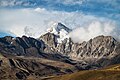
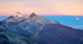 Pico Humboldt at sunset (from Andes)
 -

-
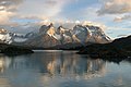 View of Cuernos del Paine in Torres del Paine National Park, Chile (from Andes)
 -

-
-
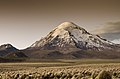
 Nevado del Huila, Colombia (from Andes)
 -

-

-

-

-
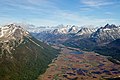 Aerial view of Valle Carbajal in the Tierra del Fuego. The Andes range is about 200 km (124 mi) wide throughout its length, except in the Bolivian flexure where it is about 640 kilometres (398 mi) wide. (from Andes)
 -

-
 Frederic Edwin Church, Heart of the Andes, 1859. (from Andes)
 -

-
-
 Laguna de Sonso tropical dry forest in Northern Andes (from Andes)
 -
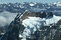
 Parinacota, Bolivia/Chile (from Andes)
 -
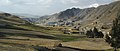
 Peruvian farmers sowing maize and beans (from Andes)
 -
 Bolivian Andes (from Andes)
 -
 Irrigating land in the Peruvian Andes (from Andes)
 -
 A male Andean cock-of-the-rock, a species found in humid Andean forests and the national bird of Peru (from Andes)
 -
 Huayna Potosí, Bolivia (from Andes)
 -
 Central Andes (from Andes)
 -
.jpg)


%E2%80%93Valle_Carbajal_01.jpg)


.jpg)
Subcategories

- Select [►] to view subcategories
Subtopics
Associated Wikimedia
The following Wikimedia Foundation sister projects provide more on this subject:
-
 Commons
Free media repository -
 Wikibooks
Free textbooks and manuals -
 Wikidata
Free knowledge base -
 Wikinews
Free-content news -
 Wikiquote
Collection of quotations -
 Wikisource
Free-content library -
 Wikiversity
Free learning tools -
 Wiktionary
Dictionary and thesaurus
-->