
Wikipedia:Featured picture candidates/Texas Highway Planning Map
Voting period is over. Please don't add any new votes. Voting period ends on 17 Mar 2014 at 23:50:01 (UTC)
-
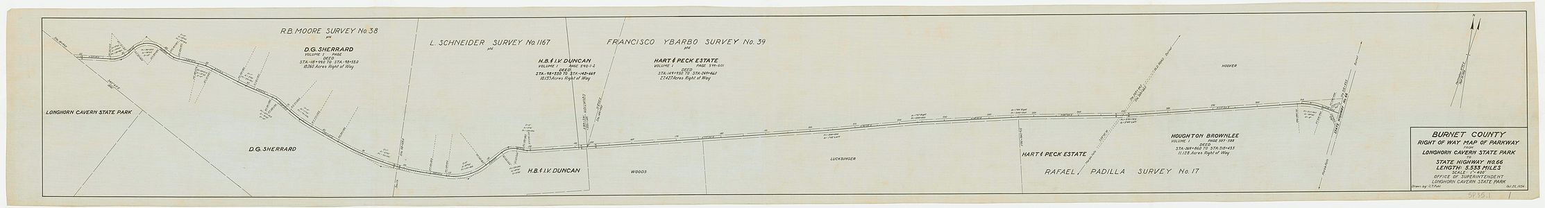
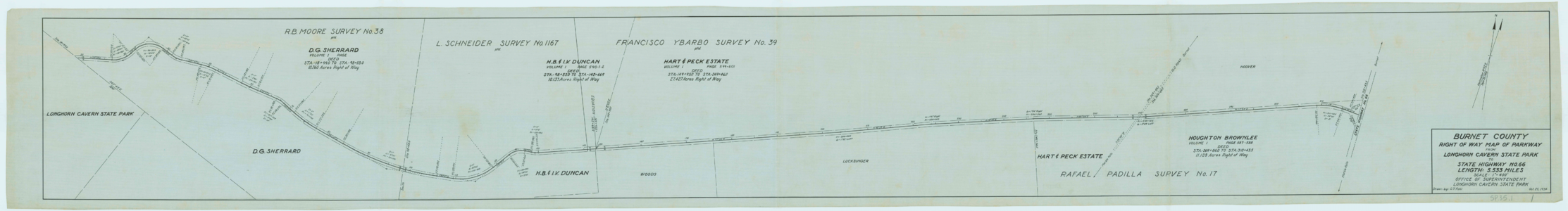 Original – A Civilian Conservation Corps planning map for the routing of a parkway. The route, built in 1934, connected Longhorn Cavern State Park to Texas State Highway 66, and would later be designated as a part of Park Road 4.
 -
 ALT - Warmed


- Reason
- Kind of an unusual image, this is a large and high-quality scan of a highway planning map. Usually, these things are drawn up by state highway departments, who rarely release them and when they do, it's under a strict copyright. This one is made by the Civilian Conservation Corps, so its PD, and it provides a great glimpse into road planning. It shows the right-of-way, distances, and all sorts of measurements that I have no clue what they represent, among other things.
- Articles in which this image appears
- Transportation planning, Civilian Conservation Corps, Longhorn Cavern State Park
- FP category for this image
- Diagrams, drawings, and maps/Maps
- Creator
- Drawn by C.T. Fohl, uploaded and minor restorations (removed a hole and a few stray pencil marks) made by Awardgive
- Support as nominator --Awardgive. Help out with Project Fillmore County 23:50, 7 March 2014 (UTC)
- Support I think the markings are mostly noting road curvatures as parts of circles: radius, angle of arc, and so on, to attempt to give the exact details of the road curves. Adam Cuerden (talk) 16:59, 8 March 2014 (UTC)
- Comment Looks very blue-tinted to me. --Paul_012 (talk) 18:34, 9 March 2014 (UTC)
- It's clearly just the colour of paper used (look around the edges, where the fading makes it more obvious that it's just coloured paper. ). I presume it has some significance, though I couldn't say what. Adam Cuerden (talk) 01:39, 11 March 2014 (UTC)
- Why is the background also blue, though? Paul_012 (talk) 14:50, 11 March 2014 (UTC)
- That's a good question. Let's see what happens when we adjust that to white. Adam Cuerden (talk) 16:33, 14 March 2014 (UTC)
- Somewhat more faded-looking blue paper. Crisco 1492, you want to have a look at this one? Adam Cuerden (talk) 16:48, 14 March 2014 (UTC)
- I've added an alt, warmed in Lightroom. I agree that this blue is an issue (which is why I've been avoiding this nom). The light blue is completely plain, suggesting it's not paper (to me, at least). — Crisco 1492 (talk) 23:28, 14 March 2014 (UTC)
- @Crisco 1492: I can far more believe blue paper than green ink, frankly. And, while I could easily believe the image was too blue, I can't for a moment believe that a group would scan an image, make it completely blue when it wasn't, and not see a problem. Colour coding by paper is done. A "pink slip" for instance, or when using carbon paper to make copies, different colours get used to show which goes to who (often white, pink, yellow). I have seen cards of blue paper before used for various purposes, and I don't think the Alt is likely to be true. Adam Cuerden (talk) 18:35, 15 March 2014 (UTC)
- Adam Cuerden, I've uploaded a different color edit over my old one. The ink looks black to me now, the background is white (ish). I agree that blue paper is relatively common, and used, but that background gives me pause. — Crisco 1492 (talk) 02:22, 16 March 2014 (UTC)
- @Crisco 1492: I can far more believe blue paper than green ink, frankly. And, while I could easily believe the image was too blue, I can't for a moment believe that a group would scan an image, make it completely blue when it wasn't, and not see a problem. Colour coding by paper is done. A "pink slip" for instance, or when using carbon paper to make copies, different colours get used to show which goes to who (often white, pink, yellow). I have seen cards of blue paper before used for various purposes, and I don't think the Alt is likely to be true. Adam Cuerden (talk) 18:35, 15 March 2014 (UTC)
- I've added an alt, warmed in Lightroom. I agree that this blue is an issue (which is why I've been avoiding this nom). The light blue is completely plain, suggesting it's not paper (to me, at least). — Crisco 1492 (talk) 23:28, 14 March 2014 (UTC)
- Somewhat more faded-looking blue paper. Crisco 1492, you want to have a look at this one? Adam Cuerden (talk) 16:48, 14 March 2014 (UTC)
- That's a good question. Let's see what happens when we adjust that to white. Adam Cuerden (talk) 16:33, 14 March 2014 (UTC)
- Why is the background also blue, though? Paul_012 (talk) 14:50, 11 March 2014 (UTC)
- It's clearly just the colour of paper used (look around the edges, where the fading makes it more obvious that it's just coloured paper. ). I presume it has some significance, though I couldn't say what. Adam Cuerden (talk) 01:39, 11 March 2014 (UTC)
Not Promoted --Armbrust The Homunculus 00:30, 18 March 2014 (UTC)