
Wikipedia:Graphics Lab/Map workshop/Archive/Sep 2024
| This is an archive of past discussions about Wikipedia:Graphics Lab, for the period 2023. Do not edit the contents of this page. If you wish to start a new discussion or revive an old one, please do so on the current main page. |
 | Archives of 2023: January, February, March, April, May, June, July, August, September, October, November, December |
Percent of scheduled tribes in India by tehsils by census
{{stale}}
-
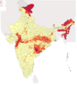 Percent of scheduled tribes in India by tehsils by census

- Article(s)
- List of Scheduled Tribes in India
- Request
- To make states and union territories boundaries more visible. Now it is almost same as for districts.--Kaiyr (talk) 16:30, 22 November 2023 (UTC)
- @Kaiyr If the base map on Commons:file:Baiga distribution.svg has all the correct borders, you have to check and tell me!
- we can use that and make a new svg version of the one you want.
- To edit the present png file like you want is hard and for the future a svg version is so much better and easier to edit. --always ping me-- Goran tek-en (talk) 12:12, 16 December 2023 (UTC)
- My map with tehsil level (subdistrict). Your map in district level. I think it is only differet. You can make this map in this site also http://www.demographie.net/atlas2001/index.html --Kaiyr (talk) 14:06, 16 December 2023 (UTC)
- Unfortunately, the vast majority of people cannot, because modern web browsers removed support for Adobe Flash many years ago now. Remsense留 14:57, 16 December 2023 (UTC)
- Ok. Lets try.--Kaiyr (talk) 16:00, 16 December 2023 (UTC)
- My map with tehsil level (subdistrict). Your map in district level. I think it is only differet. You can make this map in this site also http://www.demographie.net/atlas2001/index.html --Kaiyr (talk) 14:06, 16 December 2023 (UTC)
- @Kaiyr That link will not work for me. You have to help me here, I have zero knowledge about different divisions/levels in India.
- Have you checked what we have at commons regarding svg maps of India divided, check this category and all of its subcategories to see if you can find a better base map. --always ping me-- Goran tek-en (talk) 16:06, 16 December 2023 (UTC)
- I have cheked. Everyting is ok. Kaiyr (talk) 18:12, 18 December 2023 (UTC)
- @Kaiyr That link will not work for me. You have to help me here, I have zero knowledge about different divisions/levels in India.
![]() Request taken by --always ping me-- Goran tek-en (talk) 11:52, 19 December 2023 (UTC).
Request taken by --always ping me-- Goran tek-en (talk) 11:52, 19 December 2023 (UTC).
Will be back with a draft. --always ping me-- Goran tek-en (talk) 11:52, 19 December 2023 (UTC)
- @Kaiyr I just want you to know I'm working on it but I have also been trying to find a vector map down to tehsils. I have now found a dataset which I'm converting to a usable svg which I can upload as a base map with the three different levels. We can then use that for your request and for future usage. So it will take some more time. --always ping me-- Goran tek-en (talk) 13:20, 22 December 2023 (UTC)
- .So @Kaiyr I now have a draft for you for the basemap down to tehsils.
- ----
- Those drafts are PNG versions of the original SVG file I'm working in and will upload to commons.
- Those drafts are shown for proofreading only.
- ----
- The colors are picked so that they work for most people even with color deficiencies.
- So check this basemap and let me know if it will work for you or what to edit, Draft basemap-1. --always ping me-- Goran tek-en (talk) 11:48, 28 December 2023 (UTC)
- @Kaiyr I would need your feedback per above, thanks. --always ping me-- Goran tek-en (talk) 15:17, 1 January 2024 (UTC)
- @Kaiyr I haven't got any feedback so now I have uploaded the basemap down to tehsils which can be used to create other maps, as I will use it to do your request here now.
- You can find it here Inda states districts tehsils by census 2011.
- Please check all the information, also links for wikipedia, wikidata and structured data.
- --always ping me-- Goran tek-en (talk) 18:02, 7 January 2024 (UTC)
- @Kaiyr I just want you to know I am working on your request. Your source map and the background map I'm using does not line up, also the tehsils are different in those maps and your source map has even smaller divisions in it. All of this makes it rather complex, difficult and circumstantial to create the svg map. But I have gotten a good bit on it and will continue, thanks for your patience. --always ping me-- Goran tek-en (talk) 10:53, 12 January 2024 (UTC)
- @Kaiyr
- Now I have a Draft-1 for you to check. It was complex to redraw so really really check everything and give me feedback, thanks. --always ping me-- Goran tek-en (talk) 15:27, 13 January 2024 (UTC)
- I cant see state borders. Kaiyr (talk) 15:45, 16 January 2024 (UTC)
- @Kaiyr Please Always ping me, thanks.
- New Draft-2 with states. --always ping me-- Goran tek-en (talk) 12:44, 19 January 2024 (UTC)
- @Kaiyr
- I haven't heard from you so I uploaded what I had. If you want anything edited just ping me, thanks.
- Now you can find it here Commons:file:Percent of scheduled tribes in India-tehsils-census 2011.svg.
- Please check all the information, also links for wikipedia, wikidata and structured data.
- If you are happy with this please put the code
{{re.solved|~~~~}}(without the ".") on this request so it can be archived, thanks. Done
Done
- --always ping me-- Goran tek-en (talk) 12:24, 27 January 2024 (UTC)
- User:Goran tek-en Thank you very much. Could you add Andaman&Nicobar if aI upload here or send to you? Can we change per cent to more presice one? 20%, 40%, 60%,80%? Kaiyr (talk) 06:19, 9 February 2024 (UTC)
- @Kaiyr Didn't see this until now, didn't get any ping, try the actual Ping
{{ping|Goran tek-en}}the next time. - Sure we can do that, send me the info I need, thanks. --always ping me-- Goran tek-en (talk) 18:21, 18 February 2024 (UTC)
- @Goran tek-en:. I have updated png file with 20%, 40%, 60%,80% and added andaman and nicobar islands.--Kaiyr (talk) 10:15, 8 April 2024 (UTC)
- @Kaiyr
- Draft added-1.
- If any of the colored areas (other than the islands) has changed you will have to tell me which, thanks. --always ping me-- Goran tek-en (talk) 15:00, 9 April 2024 (UTC)
- @Kaiyr I do need your feedback to be able to continue, thanks. --always ping me-- Goran tek-en (talk) 14:53, 23 April 2024 (UTC)
- I dont know which tehsils were changed. But I think only several. Kaiyr (talk) 17:19, 18 May 2024 (UTC)
- @Kaiyr I do need your feedback to be able to continue, thanks. --always ping me-- Goran tek-en (talk) 14:53, 23 April 2024 (UTC)
- @Goran tek-en:. I have updated png file with 20%, 40%, 60%,80% and added andaman and nicobar islands.--Kaiyr (talk) 10:15, 8 April 2024 (UTC)
- @Kaiyr Didn't see this until now, didn't get any ping, try the actual Ping
- User:Goran tek-en Thank you very much. Could you add Andaman&Nicobar if aI upload here or send to you? Can we change per cent to more presice one? 20%, 40%, 60%,80%? Kaiyr (talk) 06:19, 9 February 2024 (UTC)
- I cant see state borders. Kaiyr (talk) 15:45, 16 January 2024 (UTC)
- @Kaiyr I just want you to know I am working on your request. Your source map and the background map I'm using does not line up, also the tehsils are different in those maps and your source map has even smaller divisions in it. All of this makes it rather complex, difficult and circumstantial to create the svg map. But I have gotten a good bit on it and will continue, thanks for your patience. --always ping me-- Goran tek-en (talk) 10:53, 12 January 2024 (UTC)
- @Kaiyr I would need your feedback per above, thanks. --always ping me-- Goran tek-en (talk) 15:17, 1 January 2024 (UTC)