
Wikipedia:Wikipedia Signpost/2011-01-10/WikiProject report

Her Majesty's Waterways

- Earn Wikifavors, barnstars, real-world goodies, and even money by completing requests posted at the Reward Board.
- Attention jazz enthusiasts: Check out the new Miles Davis portal!
- WikiProject Kayaking has been refreshed and could use some help with their Outline of canoeing and kayaking.
- The January 2011 Copyedit Backlog Elimination Drive has knocked out over 200 articles in its first week. Join today to help cut down the backlog and earn barnstars along the way.


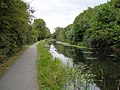
This week, we checked out WikiProject UK Waterways which focuses on the intricate system of navigable rivers, canals, and related structures that stretch across the United Kingdom. Started in April 2007, the project has grown to include 28 editors working on over 700 pages, including 3 pieces of featured material and 11 good articles. The project is a child of WikiProject UK Geography and WikiProject Transport while also collaborating with WikiProject Rivers. WikiProject UK Waterways maintains a list of open tasks and contributes to the United Kingdom Portal.
We interviewed six contributors to WikiProject UK Waterways. Ronhjones is an admin who lives less than two miles from the Lancaster Canal and owns a narrowboat on the Llangollen Canal at Whixall. Hymers2 lives near the Thames and shares ownership of a narrowboat mored at Napton. He has been cruising the canals since 1971. Jezhotwells lives in Bristol very close to the Floating Harbour. He worked for many years as a skipper/guide on trip boats in the harbour and thus has an interest in the city docks and the River Avon. EdJogg lives within reach of the Wey Navigation and the Wey and Arun Canal. He crosses the Basingstoke Canal on his daily commute. He is interested in industrial archaeology and canal restoration, although not actively participating in either, and wanted to improve related coverage at Wikipedia. Geni is an admin who aims to make sure there is an article for every canal listed in the List of canals of the United Kingdom. Rodw never added his name to the project's membership, but has interacted with the project as he became involved in canal and river articles in Somerset. He lives near the River Chew.
Why is WikiProject UK Waterways the only project on Wikipedia devoted to regional waterways? Are rivers, canals, locks, and other waterways utilized differently in the United Kingdom than in continental Europe, the United States, Australia, or elsewhere?
- geni: The UK's waterways with a few exceptions (the Manchester ship canal say) never expanded from the original small size they were built to (usually somewhere around 72ft*7ft although both bigger and smaller standards exist). Elsewhere canals tended to expand at least up to barge size but in the UK they were for the most part flat out replaced by rail. The UK's canal system is the only one I'm aware of where an entire network of canals ended up being used for leisure with no significant movement of goods.
- EdJogg: A widespread network of canals developed in the UK as there were no other practical means of bulk transport at the time. I suspect that other countries (following on from the British invention of the steam engine) moved straight to the faster transport provided by railways and then roads, except where navigable rivers of suitable size already existed. There is also a great sense of history in the UK, and a love of all things old – hence the desire to resurrect as much as possible of the original canal network for modern leisure and ecological use.
- Hymers2: Agreed with the above, with the addition of the Irish waterways. The UK and Irish systems are unique in the world in being used almost exclusively for leisure and in being largely unchanged from when they were built. Where leisure use has developed elsewhere (eg Canal du Midi) it has usually been by companies of British origin, at least initially.
What are some of the benefits and challenges of maintaining a regionally-focused WikiProject?
- EdJogg: I cannot speak for others, but my knowledge is limited to UK waterways, so a region-specific project helps maintain focus. On the other hand, there are likely fewer editors available to contribute.
- Geni: It lines up with the meatspace waterway groups. Well more correctly it combines the mostly English and Welsh coverage of groups like the Inland Waterways Association and Waterway Recovery Group with the Scottish and Northern Irish groups.
The project has three pieces of featured material and 11 good articles. Have you contributed to any of these articles? Are you currently working on bringing an article up to FA or GA status?
- Rodw: I found the guidelines How to write about UK Waterways helpful with some of the articles relating to waterways in the south west of England which I have been involved with including: River Parrett (FA), List of locks on the Kennet and Avon Canal (FL), Bridgwater and Taunton Canal (GA), Bristol Harbour (GA), Grand Western Canal (GA) & Kennet and Avon Canal (GA).
- Jezhotwells: Agreed the guidelines are good and clear. I have contributed to River Avon, Bristol Harbour and also other features of the docks and tributary rivers and streams.
- Hymers2: I have contributed expansions and revisions to several articles.
Some of the project's articles include route maps. How do these compare to the route maps for train and roadway articles? What sources of information are used to create route maps for waterways?
- Ronhjones: I have made some of these, using the standard set of icons as used for the railways, plus the necessary water only related ones. I use a combination of published guides (e.g. Nickolsons), Streetmap (OS map), Google earth, and own knowledge.
- Rodw: I've never made any of these but I'm very grateful to User:Bob1960evens and others who have made loads of them.
- Hymers2: The route maps compare well to those used for railway articles and are very useful as a means of explaining the routes.
- Jezhotwells: I have found these icons useful; and used them to make a map for New Cut (Bristol).
- EdJogg: The icons and maps were based on those created for railways, and expanded to provide the unique features. The maps are essential for describing the (arrangement of) features of a canal in a succinct manner and useful to show the alternative routes proposed or built for restored canals.
How are abandoned waterways and structures handled by the project? Do these tend to be more interesting than the waterways currently in use?
- Rodw: Lots of the old canals, including the Somerset Coal Canal near me are no longer in water, but the feature which seems to have generated most discussion is the amazing (but unsuccessful) piece of engineering – the Caisson lock.
- geni: About the only additional challenge that abandoned stuff presents is deciding what is actually abandoned. There are a lot of canals around that have bits in water and active restoration projects which can be tricky to classify (the Croydon Canal is clearly abandoned the Thames and Severn Canal is less clear).
- Jezhotwells: I agree with geni; often hard to decide what is actually abandoned. Many ambitious projects are in existence to restore waterways such as the Wilts & Berks Canal.
- EdJogg: The 'abandoned' canals are often more interesting (to me) since many are in an active state of restoration, so the articles are expanding to reflect progress. Those that aren't being restored may be less well known. Established waterways are perhaps less interesting as their current state is 'in use', although the history should be as interesting.
-
 Wilts & Berks Canal
 -
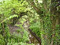 What appears to be an abandoned portion
 -
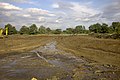 New construction on the Wilts & Berks Canal


Does the project have any difficulties acquiring pictures of waterways? Does the project's regional focus make requested photography easier to take?
- Rodw: I help by taking pictures of waterways near me – but I also find Geograph Britain and Ireland a really great source & they all have suitable licences.
- geni: Used to be but most are covered these days. Biggest problem is probably the british weather.
- Jezhotwells: Geograph is a good source. I have contributed some images to Commons.
- EdJogg: There are many hundreds of canal pictures that have been auto-uploaded from Geograph to Commons. The main problem is categorising them. Since the editors and the subject matter are in the same country, taking additional photographs presents less of a transport problem!
Anything else you'd like to add?
- Jezhotwells: Any new members will be welcomed, there is much that has still to be covered.
- EdJogg: The British canal system is a fascinating topic to study, and any editors interested in industrial archaeology or old technology will find much of interest here.
Next week, we'll watch the world's second most popular sport. Until then, stump the batsman with your superior knowledge of WikiProjects by reading through the archive.
Discuss this story