
Wikipedia:Wikipedia Signpost/2012-04-30/WikiProject report

The Cartographers of WikiProject Maps

- The May Copyedit Backlog Elimination Drive has begun.
- A new issue of Ichthus has been published by WikiProject Christianity
- A new project has been started to prepare Wikipedia for the launch of the new IPv6 internet addressing protocol in June
- The Counter-Vandalism Unit has undergone an overhaul and has absorbed WikiProject Vandalism Studies
- The Multilingual Challenge sponsored by the Teyler's Museum runs until the end of May
This week, we located WikiProject Maps. Launched in February 2004, the project has grown to 4,000 articles and files, including five featured articles and one good article. The project maintains guidelines for creating and editing maps while teaming up with the Graphic Lab to provide a workshop for mapmakers. We interviewed EdwardLane and Yug.
What motivated you to join WikiProject Maps? What is the most interesting map you have uploaded or edited?
- EdwardLane: I've always been interested in maps as I like to imagine there are dragons in the unexplored spaces. I joined WikiProject Maps when I realized that I kept coming back for answers to cartography-related questions. I've not (yet) made a map for Wikipedia, but I do aim to.
- Yug: "Maps is emotion". I naturally have a visual profile. Images, drawings, attract me a lot. But after years to look at, work with, and design maps, I realized that for me, maps are "emotions". When looking at a map, I can read the core dynamics, the strategic places, the balance of powers, the populations moves leaving the insecure areas then flooding toward more secures cities, or richer lands. It's both intellectually challenging and emotionally touching. It's how I currently explain my odd fascination for maps.
- My involvement for the Map project is a by-product of this attraction for maps, knowledge sharing (ie: editing Wikipedia), and my leadership within the Wikipedia:Graphic Lab created in 2005. Following the need for graphics, the Graphic Lab has since spread into a dozen language teams (en, de, fr, es, it, ru, ...) and improved or created from requests about 15,000 images and 5,000 maps so far. Request after request, maps appeared to be a core media for Wikipedia: clean, semantically rich, communicative. But the situation was quite messy, with hundreds of independent map styles, icons sets, color sets, and naming conventions. With the assistance of wiki-friends, I've led a six-year effort to make sense of this, drafting the current Wikipedia map conventions.

While the majority of the project's assessments are for image files, some articles are included under the project's scope. What kinds of articles are these? What difficulties does the project face when improving articles under its scope?
- EdwardLane: The scope has recently expanded to include improving all map- and cartography-related articles, WikiProject Maps was originally (and still is) focused on creating maps when people request maps on the talk page for articles using templates like {{reqmapin|somewhere}}.
- Yug: The Map project members are massively graphists with visual-oriented profiles. We lack encyclopedic/academic profiles to do scholarly researches to write good and featured articles. The very top priority is the article cartography, which is currently quite messy (the French version provide a good outline for anyone willing to launch a such rewriting).
How often do territorial disputes, civil wars, and disasters result in map changes? How does the project handle territories claimed by more than one government or group? What steps can the project take to prevent editors from altering maps to match their national or political point of view?
- EdwardLane: Well, synchronicity strikes; WikiProject Maps has just had some bickering on this subject brought up in a RFC, and I feel a bit like ArbCom, having just worked out what I think would be an appropriate NPOV solution.
- South Sudan's recent split from Sudan also triggered a reasonable amount of action from WikiProject Maps (and others) to update the relevant template maps. There are always changes ongoing, but making a map for Wikipedia means you need well-sourced data for the map, and that seems to solve most of those issues. Political issues between the de facto and de jure control of a territory on maps do raise issues, but mostly just portraying both boundaries or labeling the map correctly resolves those. And listing the source of the data in the meta-tags at least lets you know what it is showing.
- Which national/political view is portrayed in a map will always be affected by the cartographer, I'll try to quickly explain cartographic generalization.
- Imagine you could draw a perfect map of the US: on what scale do you draw it, and is there room for a particular city to be labeled – that's a political choice. For example, on Google maps, Baltimore only gets a label when you zoom in five times, while Philadelphia appears after three zooms, New York and Washington after four. Is there a reason? Well it's mostly to do with space on the map, as Philadelphia is probably not "more important" than Washington and New York, but is probably more important than the other names that could be written in that space and still be in the right spot.
- Making those sorts of calls will always have political significance, or at least involve a value judgment, Cartography is in many ways all about deciding what you want the map to show, historically kings and emperors have paid good money to get a map showing their realm to be more powerful/influential/successful/pious than their neighbors.
- Yug: More recently, an endless dispute over the People's Republic of China's map and its territorial claims opened again. ArbCom requested that WikiProject Maps suggest a fair/NPOV graphic solution. Edward and I defined the needs and are currently examining maps, collecting the current Wikipedia practices, and will soon suggest a new map convention for disputed areas.
-
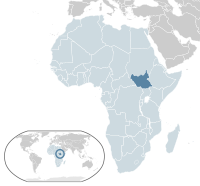 The new country South Sudan (dark blue) was added to map templates in 2011
 -
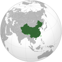 An orthographic projection showing the internationally recognized territories of China in dark green and disputed territories in light green
 -

.svg)

Do you tend to see political or physical maps used most frequently on Wikipedia? Is one preferred over the other? What are some unusual or unique types of maps included in Wikipedia articles?
- EdwardLane: Maps are not all about the "perfect" depiction of geography: some show the stars, some show how many people voted in a particular election, some show fictional worlds, some are abstract concept maps, some show the surface of other planets, or like the London Underground Map distort real geography to make a map which is much easier to read.
- Yug: Administrative maps are the most common maps displayed across Wikipedia. Its norm is nowadays called "location maps" (guideline here) : a grey based map with administrative limits. They are frequently used as base maps for more complex maps such as animals ranges, election maps, as well as more complex historical maps —the maps within the history—, which are a critical element of an encyclopedia's map landscape. Other kinds of maps such as cartograms are also present in wikipedia, while rare.
-
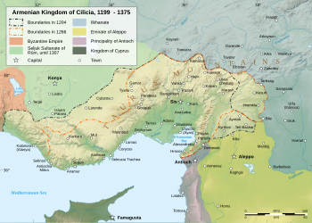 History of Cilicia, upon a topographic background explaining widely the human occupation.
 -
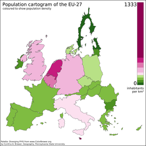 A cartogram depicting a distorted European Union showing population distributions by size and color


How was the standard palette of colors selected for Wikipedia's maps? Has this color scheme caused any difficulties when building complex maps?
- EdwardLane: Check out Wikipedia:WikiProject_Maps#Map_colours – and Wikipedia:WikiProject_Maps/Conventions I don't think they have caused any problems.
- Yug: In the earliest history of Wikipedia map-making, the CIA orange maps and grey-green png maps were the norms, aside from hundreds of independent styles. Between 2006 and 2007, two palettes of colors emerged: the 'Indian Project' palette was proposed by Planemad alone, and spread for a time. Its colors are quite vivid, and derived from the earlier CIA maps palette. In parallel, the French cartographic workshop team discussed and built a comprehensive palette with an incremental approach. Users STyx, Sting (Brazil), Sémhur, Yug (myself), NorthNorthWest (Germany) each made significant proposals that were enthusiastically commented on, improved, and implemented. This last palette was from the start conceived for the specific use of Wikipedia. The CIA colors were dropped for both moral/political and pratical reasons, the wiki gray was kept, softened, and enriched by web and screen friendly colors to create and strengthen Wikipedia's maps identity, topography —which often explain demographic occupation, history, battles— was pushed forward, while a set of standard icons and labels was provided. The aim was to coordinate map creations among map creators, with an semi-professional, standardized style increasing Wikipedia's maps readability and credibility. Since then, this palette (File:Maps_template-en.svg) is the real cornerstone of our coordinated effort. Within the public domain, it allows any cartographer to use this toolkit of elegant colors, icons, labels within his/her maps. These styles have been explained in our Map conventions pages, with some further improvements and alignments still planned.
Do any of Wikipedia's maps employ fictitious entries similar to the "copyright traps" used by some professional mapmakers? How can the average reader be sure of a map's accuracy without checking another source?
- EdwardLane: Not that I'm aware of, though some might be inherited from the original source; but ideally the reliable source of the data should be listed in the map's meta-data. It's a nice question though.
What are the project's most urgent needs? How can new writers and mapmakers help today?
- EdwardLane: Writers can no doubt help clean up the language and organize the cartography and map articles – they both need a fair chunk of work. If someone can organize all the various types of map projections and make sure we've not missed any in the Template:Map Projections, that could tidy things up a lot too. If you want to start making maps, say hello on the WikiProject Maps talk page. You could check out these links to tutorials, or we can point you at lists of requested maps.
- Yug: We currently seriously need new SVG mapmakers. We recently finished a tutorial with SVG exercises for map-making. If you're interested in learning map-making, that's the place to start. We currently have dozens of requests in the backlog for map creation – which are dozens of learning opportunities!
.svg)
- For the future, I personally think that map-making and image creation in general now need a stronger and ACTIVE support from the Wikimedia foundation. Wikipedia is both text (wiki editor system) and images, with maps having a special place. Some innovative technical solutions and projects are already financed by the Wikimedia Foundation on the editing side. Serious and professional technical innovations projects are needed for images and maps as well. A good direction, for example, would be the development of a free on-the-cloud global map-making system similar to Google-map. Sharemap.org is creating a such online system specifically for encyclopedic maps and Wikipedia, but currently without any official support. But as for other heavy-coding projects, only some financial support can avoid failure and keep them going to improve the Wikipedia map sites. I sincerely wish the foundation can wake up and support this graphic side of its projects.
Next week, we'll learn a new language. Until then, practice your linguistics in the archive.

Discuss this story